

National Fire Plan Success Story
Charlton-Chilao Vegetation Treatment Project
Los Angeles River Ranger District, Angeles National Forest
National Fire Plan - Fuels Reduction
2008
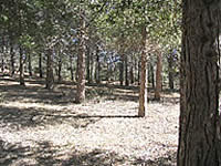
A treatment area within the Charlton-Chilao Vegetation Project.
This project is located within the Charlton-Chilao Recreation Area and administrative sites on the Angeles National Forest (San Gabriel Mountains) just northeast of Los Angeles. The area is approximately 8,500 acres of mixed conifer, ponderosa pine, Coulter pine, canyon live oak, and mixed chaparral at 3,650 to 6,200 feet in elevation.
The treatment area encompasses a variety of national forest picnic areas, campgrounds, a visitor center, several hiking trails (including the Pacific Crest Trail), a scenic byway, and five youth organizational camps. These facilities receive extremely high recreational use, drawing tens of thousands of visitors from the city, especially on summer weekends. They are also deemed at risk from catastrophic fire.
A Cal-Trans maintenance yard, an observatory, Forest Service fire station, helicopter base, and two parcels of private property are also within the project area. These areas will experience the same benefits from the treatments.
The activities during the treatments include hand cutting / piling, pile burning, broadcast burning, mechanical treatments (mastication) and public education. The treatments are designed to improve forest health and vigor in plantations as well as natural tree stands for a greater resistance to fire, insect attack, and disease. Because of the treatments, wildfire intensity will be diminished, better protecting the improvements in the project area from fire and allowing forest visitors more time to evacuate.
Multiple resources were involved in the project planning and include the district resource officer, fire/fuels staff, Arc/GIS staff, biologists, botanists, archaeologists, recreation staff and air, soil, and watershed specialists. Contractors were also utilized for both the planning and implementation phases of the project.
This project involved scoping and public notification of 154 different agencies, groups, and individuals. The project was implemented in FY06 and is expected to take eight years to accomplish. Three hundred ninety (390) acres of forest was treated using a masticator and 600 acres of work by hand crews (manual thinning) were completed in FY 2007.
Contact: Scott Lowden, District Fuels Tech. (818)-899-1900, slowden@fs.fed.us.