
National Cohesive Wildland Fire Management Strategy Success Story
State of Maine, National Park Service, and Local Partnerships Provide Community Wildland Fire Protection
Acadia National Park, Maine
Cohesive Strategy - Maintain and Restore Resilient Landscapes
2012
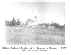
A 1937 photo of Baker Island shows the lighthouse and keeper's house. Photo by Milton Lord.
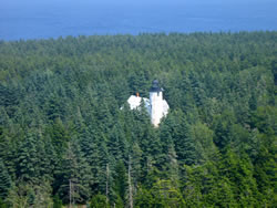
Baker Island in 2012, prior to treatment.
Baker Island in 2012, prior to treatment.
Baker Island is a 140-acre unit of Acadia National Park located four miles from the mainland. Historic buildings on the island include a lighthouse, a barn and oil house, a home belonging to the original settlers, and two private residences.
Residents lived on the island year-round as early as 1806 and for almost 150 years thereafter. They supported themselves by fishing, raising potatoes, and pasturing sheep. Islanders cut down virtually all trees by the late 1930s for building material and fuel. Grazing and tilling suppressed regeneration.
The last permanent residents left the island shortly after World War II. Coastal spruce immediately colonized ninety percent of the island, producing dense forest with isolated patches of birch, poplar, and Mountain ash. By 2012, the forest had grown to a height of over 60 feet, completely enclosing the lighthouse and other buildings.
Though coastal Maine is generally wet, it can and has burned with great intensity and with very rapid spread rates. The long fire return interval and lack of human intervention since the departure of the island residents resulted in extreme fuel build-up. In addition, with the added factors of strong winds that commonly blow in from the North Atlantic Ocean and the routine, unregulated visits by the public during fire season, there was a real danger that a wildfire could start. There was a strong likelihood that if a wildfire started on the island, the historic buildings would be damaged or destroyed.
The park’s fire management program partnered with the park cultural resources program to create a plan for a fire resistant landscape on the island, as a suppression response could be difficult given the many logistical challenges. The same logistical issues confronting suppression response confronted fuels reduction planning. The plan outlined that coniferous trees would be thinned or removed and deciduous trees left in place. The job was to be completed by a contractor to reduce NPS logistical involvement and enhance biomass utilization and economic development, however, the low bid received was over four times the project budget. The bid was rejected, and the National Park Service enlisted numerous partners to complete the project. NPS personnel would cut, pile, and burn the leftover biomass. The University of Maine Forestry students marked the treatment area boundaries. Bar Harbor Whale Watch Company, the College of the Atlantic, and the Acadia NP Maintenance and Visitor Protection divisions provided boat support. The friends group, Keepers of Baker Island, provided a tractor and operator to ferry supplies from the landing site at the shore to the camp, and to skid biomass to burn sites. Acadia interpretation rangers managed messaging. Numerous public meeting were held with local governing and advisory bodies for outreach about the project.
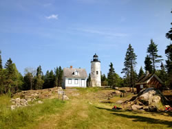
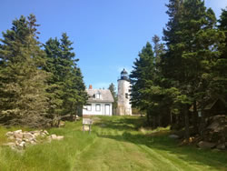
Baker Island after treatment in June 2012.
On June 11, the Cape Cod National Seashore fuels crew and several Acadia firefighters were put ashore along with nearly three tons of fresh water and supplies. A detailed Incident Action Plan was written to provide guidance for the 12 days of work, with particular attention given to medivac and communication plans. Input from numerous members of the Acadia resource management staff was solicited to ensure sensitivity in the fragile island ecosystem. The successful outcome and excellent safety record of the project was a direct result of the planning that went into it. The resulting defensible space on Baker Island created an aesthetically pleasing landscape that is less vulnerable to wildfire.
Credit for success goes to all who participated. Through its collaboration with public partners, this project meets the NPS’s A Call to Action goals of promoting landscape conservation to support healthy ecosystems and cultural resources.
Contact: Andy Mitchell, Acadia/North Country Fire Management Officer, Andy_Mitchell@nps.gov, 207-288-8780
Keywords: landscape restoration, defensible space, public partnership, Cohesive Strategy, Call to Action, wildland fire training