

National Fire Plan Success Story
Successful Partnerships Save Homes
Cleveland National Forest
National Fire Plan - Community Assistance
2007
Background
During the fall of 2003, the residents of Palomar Mountain in the Cleveland National Forest watched as the Paradise fire threatened their community, only to turn away when the winds shifted and rains arrived. This fire was a wake-up call for residents in the communities on Palomar Mountain. Like many others in mountain communities, they enjoyed the rural lifestyle, with homes tucked away underneath the trees, and reachable only on narrow bumpy dirt roads.
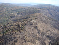
Fuel reduction on Palomar Mountain protects approximately 300 homes in the local community.
After the Paradise fire, people realized that wildfire was a real threat to their homes and the forest environment where they lived. A local Fire Safe Council (FSC) was formed and this group developed the Palomar Mountain Community Wildfire Protection Plan (CWPP) that identified needed treatments and set priorities. Projects included logging, chipping, mastication, goats, and public education. Treatments were located at the top of Palomar Mountain near the community, where firefighters would be able to take advantage of a change in topography and a reduction in fuels in the event of a fire.
The FSC also arranged purchase of fire gel to be applied by homeowners to their homes in the event of an approaching wildfire. This gel was used on homes in the area and some homeowners credit the gel, defensible space, and fire suppression efforts with saving their homes. Each of these projects were funded through State Fire Assistance (SFA) grants.
Two USFS Projects Provide Public and Firefighter Safety
The Palomar Mountain project included multiple projects with partners and two USFS treatments. The Birch Hill Mastication Project was completed in 2004 and consisted of the removal of 84 acres of brush directly below (down slope) of the community of Birch Hill, home to approximately 300 residences.
Although the Poomacha Fire did not advance into the Birch Hill portion of the project area, it was evident that if it had, there would have been a dramatic change in fuel loadings and fuel density that would have allowed suppression resources to be successful, both from the ground and from the air. Conversations with locals revealed that prior to the mastication, brush was 8 to 10 feet tall, with densities that did not allow for foot travel. Currently, brush is in the 1-4 foot range with scattered small openings which was easily accessible by foot travel.
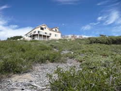
Mastication on Birch Hill.
The second USFS Project Area is a roadside thinning project along the S7 road, which accesses the communities of Birch Hill and Crestline from the valley floor in Valley Center, and along the main State Park Road. This project is unique in that it was planned to enhance the evacuation corridor for the residences of both Birch Hill and Crestline communities and State Park users. The project consisted of thinning brush 100 feet on both sides of State Route S7 and State Park Road, combined with removal of dead and/or dying trees within 100 feet of State Route S7 that would restrict traffic flow in the event of a wildfire.
Both stages of this project proved effective during the Poomacha Incident. The thinning of brush allowed firefighters safer access to the slope so that a more controlled backfire could be lit using drip torches.
The removal of dead and dying trees along State Park Road and Route S7 may have been the single most important contributing factor to public safety during this event. If dead and dying trees were allowed to remain along both Evacuation Corridors, it is believed that due to hurricane force winds, many trees would have fallen, blocking the escape of residents in the Crestline and Birch Hill communities. As a result of this project, there were no instances of trees blocking the road. Evacuations and firefighter access to the area proceeded in a safe and timely manner.
In addition to these projects, it was evident that many home owners in the communities of Birch Hill and Crestline and other residents on Palomar Mountain have become aware of the need to make their properties more fire resistant and accessible to suppression resources. During the firestorms of 2003, the Paradise fire came very close to threatening these same mountain communities. Private landowners in and around structures have accomplished much work in the past 3 years.
Success through Collaboration
Partners for these projects include United States Forest Service, Natural Resource Conservation Service, Palomar Mountain Volunteer Fire District, Palomar Mountain Fire Safe Council, California State Parks, San Diego County and private landowners. Each of these agencies and landowners work together as members of the Forest Area Safety Taskforce (FAST).
Contact
Kathy Murphy, Pacific Southwest Regional Fuels Manager, 530-587-3558 ext 245.