

National Fire Plan Success Story
Eagle School Children and AK NPS Fire Management Track
Forest Succession Following Intense Fire Season
Yukon-Charley Rivers National Preserve, Alaska
National Fire Plan - Community Assistance
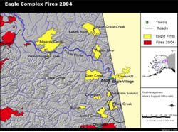
Map of the 2004 Eagle Fire Complex at Yukon-Charley Rivers National Preserve and surrounding areas.
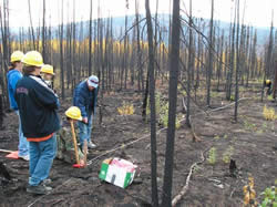
Eagle students and high school teacher take measurements at a fire effects plot on September 9, 2005.
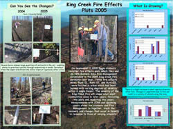
2005 King Creek Fire Effects Plot Poster.
In 2004 wildland fires surrounded the small community of Eagle, located south of Yukon-Charley Rivers National Preserve. Smoke and incident management teams impacted the community from early June until mid August. In an effort to help the local school children make sense of the intense wildland fire season that occurred around them, NPS fire management staff presented a two and a half day fire ecology educational program at the Eagle Community School in early September of 2004.
On day one, a total of 20 school children, ages ranging from K-12, teachers and fire staff collectively recounted the locally significant fire events by reviewing fire perimeter maps given to them from the incident management teams. Teachers and students also learned about the role of fire in the boreal forest. On day two, ten 9 to 12th grade students, the high school teacher and fire staff visited a July 2004 burned forest within the King Creek Fire perimeter. At the burned area, fire staff led the group in establishing three fire effects plots. Burn-01, Burn-02, and Burn-03 were located in areas which burned with varying degrees of severity.
At each plot, using a point intercept measuring method, students determined plant and ground cover and documented their findings on data sheets. They took frame related measurements in order to determine the burn severity index, percent cover estimates for vegetation, forest floor and substrate and permafrost depths. They recorded the data on data sheets and took photos. On day three, fire staff interpreted the data for the students and concluded the program with a discussion about the response of the forest to fire. Following the program, fire staff created a 2004 King Creek Fire Effects Plots poster for the students.
Every September, Eagle students and fire staff revisit the fire effects plots that were established in 2004. They take measurements and photos from the same locations as previous years and complete data sheets. During the winter, fire staff analyses the data, displays the results in a poster and sends it the students. This unique program allows students and fire staff to accomplish a common goal of tracking the succession of a boreal forest after fire. Rather than a summer's inconvenience, Eagle students learn that fire is a significant force of nature that contributes to the health and beauty of the landscape that surrounds their home.
Contact: Morgan Miller, AK NPS Regional Wildland Fire Communication and Education Specialist
Phone: (907) 683-6423