

National Fire Plan Success Story
Wildfire Season 2007 Tests Fuels Treatments in the Wildland-Urban Interface
Cottonwood Field Office, Idaho
National Fire Plan - Fuels Reduction
Fire Season 2007 proved to be a very busy one for the Cottonwood Field Office in north central Idaho. Three large wildfires burned a total of 115,000 acres, of which 21,000 acres were on BLM ground. Two of these fires, burning within the wildland-urban interface, threatened multiple homes and communities and put previous fuels treatments to the test.
The Chimney Complex burned over 51,000 acres in the Craig Mountain area south of Lewiston, Idaho, threatening the community of Waha Glen. The Craig Mountain area, which provides unique wildlife habitat along the lower Snake River, is cooperatively managed by the Bureau of Land Management, Idaho Fish and Game, Idaho Department of Lands, and The Nature Conservancy.
In October 2006, BLM, IDFG, and IDL conducted an interagency prescribed burn to reduce fuels and provide a buffer between the fire-prone landscape of the Craig Mountain area and the community of Waha Glen. The 1,600 acre Madden Creek prescribed burn provided an opportunity to successfully stop the Chimney Complex from advancing toward the structures in and around this community. Evacuations were in place for over 3 days, but residents eventually returned to find their homes intact.
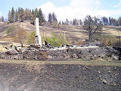
Light fuel loads and vulnerable structure material lead to complete loss of several structures to the Poe Cabin wildland fire.
Further south, along the Snake River in the Hells Canyon National Recreation Area, the Poe Cabin fire raced through the upper Deer Creek rural development with extreme wind-driven fire behavior. Residents had little time to prepare or escape, but remarkably few structures were lost. This was not a matter of luck.
In 2004, several of these residents had joined together to develop a plan and conduct defensible space treatments in an effort to reduce fuel accumulations. A combination of dense brush, steep terrain, the presence of beetle-killed trees, and over fifty years of fire suppression had created a dangerously high level of wildfire risk. This work was accomplished with assistance from local Forest Service, Framing Our Community and Clearwater RC&D. All structures involved in this program were spared, while 12 structures that had not undergone defensible space treatment were lost to this fire.
Wildfire events like the Poe Cabin Fire can happen in a variety of environments. When living in these locations its necessary to identify hazards, means of fuel reduction, and the appropriate steps needed to lessen the damage. In the case of upper Deer Creek, a number of homeowners had the foresight to take action long before the fire occurred and a greater loss of structures was prevented.
In the wake of the Poe Cabin Fire, an educational moment is being captured on video for others to share. The Forest Service, BLM, IDL, and Framing Our Community have joined together in the production of a professional video to be completed in the fall of 2008. This video will be distributed throughout the agencies, rural fire departments, and counties in an effort to reach a wide audience and share stories of success and necessity for defensible space treatment around homes.
Additionally, in 2007, the local BLM, Forest Service and Salmon River Rural Fire Department, with support from Idaho Department of Lands, Clearwater RC&D, and Student Conservation Association, have partnered to conduct Red Zone homeowner fire risk evaluations along the Salmon River corridor. This is a multi-year project, involving 800 plus homes scattered up remote drainages and steep hillsides along the fire-prone Salmon River landscape.
The most immediate outcome from this effort is homeowner education. These interviews often provide the impetus for many homeowners to take immediate action to mitigate hazards once they are identified. The data collected can be consolidated into the Red Zone database which can be shared with the fire protection agencies, county, rural fire departments, and incident management teams in the event of a wildfire. This data may also be used to identify opportunities and prioritize projects for grant money applications.
Contact: Kristen Sanders, Fire Ecologist, Cottonwood Field Office, 208-962-3786