

National Fire Plan Success Story
Highway 39/ East Fork Road Junction
San Gabriel River Ranger District, Angeles National Forest, California
National Fire Plan - Fuels Reduction
2008
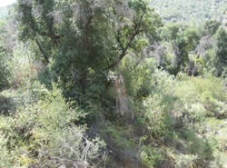
This oak stand was heavily overgrown with brush and vines, creating a continuous fuel profile from ground level up through the canopies of the oaks.
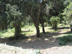
Crews have gone in and removed the under story brush species and trimmed up the oak trees.
The project is located along State Highway 39, in San Gabriel Canyon, on the San Gabriel River Ranger District of the Angeles National Forest. The project site is a natural oak stand, growing on a bench above the San Gabriel River, at the junction of Highway 39 and East Fork Road. This grove extends for approximately a mile, north along Hwy 39 to the Rincon - Shortcut Trailhead.
Highway 39 is a major route for recreational traffic into and out of the Forest. The canyon draws over 1 million visitors per year, with concentrations of Forest users extremely heavy on weekends. Recent fire history in the area includes the Curve Fire (2002), during which over 10,000 members of the public were safely evacuated from the canyon when access to alternate routes was pinched off.
This oak stand was heavily overgrown with brush and vines, creating a continuous fuel profile from ground level up through the canopies of the oaks. Fires in these conditions were high intensity and stand replacing.
Crews have gone in and removed the under story brush species and trimmed up the oak trees. Removed fuels were chipped and disposed of on site. Forty acres of natural canyon live oak were treated. Plans are progressing to be able to maintain this stand with low intensity prescribed fire every 5-10 years to mimic the effects of wildfire in reducing and maintaining the under story within the stand.
The resulting desired condition after the treatment is less prone to high intensity, damaging fires. This reduction in fire intensity will also serve as a buffer along Highway 39, the heavily used route for recreational traffic and the only way out of the canyon.
This is an on-going project, with the first treatment in the project area having been completed in 2003. The East Fork Oak Stand project is located within the district of Congressman David Dreier.
Project Contact: Byron Kimball, San Gabriel River Ranger District Fuels Specialist, at (626) 335-1251 x 228, bkimball@fs.fed.us.