
Forests and Rangelands Success Story
Mesa Pedregosa Fuels Reduction
Pagosa District / Field Office, San Juan Public Lands, Colorado
National Fire Plan - Fuels Reduction
2008
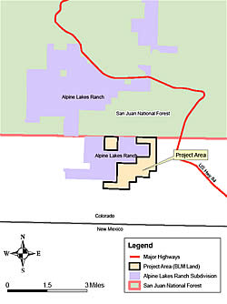
Mesa Pedregosa Fuels Reduction Project Area map.
The Mesa Pedregosa Fuels Reduction and Forest Health Project area is located within 1,177 acres of BLM lands on the Pagosa Ranger District/Field Office of the San Juan Public Lands in southwest Colorado. The project area, located within the Wildland Urban Interface, encompasses three mesas intersected by steep canyons and ranges in elevation from 6,500 to 8,200 feet. It is bordered by San Juan National Forest to the north and by private property on three sides. The Alpine Lakes Ranch subdivision, comprised of over two hundred 35-acre "ranchettes," borders the project on the west and occupies an inholding surrounded by public land. Several houses are less than 1/4 mile from treatment unit boundaries.
San Juan Public Lands is a Service First organization with joint management responsibilities for both US Forest Service and BLM land. The Pagosa District/Field office began holding public meetings and field trips in 2002 with residents of Alpine Lakes Ranch to discuss fire hazard and possible fuels reduction projects on adjoining US Forest Service land. The fire hazard conditions on Mesa Pedregosa were brought to the District’s attention by nearby homeowners. In May 2006, 24 residents of Alpine Lakes Ranch attended a public field trip into the project area. All expressed support for the project.
Much of the Mesa Pedregosa project area is unique in that it has not been logged and contains numerous 200 to 400 year-old ponderosa pine trees. Due to over 100 years of fire exclusion, the once open ponderosa pine forests are now choked with juniper, white fir, and Douglas-fir. The area is at high risk of severe stand replacement fire with over 30 tons of hazardous fuels per acre on the mesa tops and more in the canyons. Bark beetles have recently killed numerous ponderosa pine, Douglas-fir and white fir trees, especially in the canyons. The older pine trees are especially vulnerable.
In June of 2004, fire crews suppressed a 30-acre wildfire in the project area that had significant potential and helped to raise concerns among the residents in the area.
The project involves mechanical mowing/shredding of understory vegetation (Gambel oak, Rocky Mountain juniper, white fir, Douglas-fir and ponderosa pine) on approximately 400 acres in 6 treatment units, followed up by prescribed burning in 4 of the 6 units. The emphasis of the mowing is to remove ladder fuels, thin dense clumps of trees, enlarge existing openings, and create new openings in the canopy. The objectives of the treatment are to reduce the risk of crown fire, reduce competitive stress on older ponderosa pine trees, and remove non-fire resistant species such as juniper and fir. The first phase of mowing took place in the summer of 2007 on 200 acres in four units. The remaining treatment units are scheduled for mowing in 2008.
This summer, a burn plan will be prepared and the first prescribed burns are scheduled for next fall or the following spring
Contact: Scott Wagner, Fuels Forester, Pagosa Public Lands Office, at 970 264-1511 or wagner04@fs.fed.us.