

National Fire Plan Success Story
Complex Multi-agency Burn Completed
Canaveral National Seashore, Florida
National Fire Plan - Fuels Reduction
2008
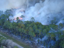
Burning out along powerline at Canaveral National Seashore. Photo by Jeff Schardt, Merritt Island National Wildlife Refuge.
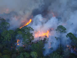
Dangerous fuel loads are reduced after long fire absence at Canaveral National Seashore. Photo by Jeff Schardt, Merritt Island National Wildlife Refuge.
Bills Hill, a 1,088-acre tract on the mainland portion of Canaveral National Seashore, consists primarily of undisturbed scrubby flatwoods and oak scrub. It possesses a distinctively wild quality not found elsewhere in the Seashore. It also presents complex issues for fire management. Years of fire suppression have allowed heavy fuel loads to accumulate thus threatening the rural community of Oak Hill, just north of the Seashore's boundary. U.S. Highway 1 and State Road 3 lie just to the west, raising significant smoke concerns. An area co-managed with USFWS sits directly to the south, raising potential for wildfire to escape into this "joint" area. Careful application of prescribed fire was urgently needed to reduce this threat.
Prescribed fire was also needed to restore habitat for several federally protected species, including the Florida scrub jay, Eastern indigo snake, and bald eagle. Open areas had become overgrown, greatly reducing suitability of habitat for these species. Young pine seedlings were being crowded out, significantly reducing number of potential nest trees for the eagle.
To perform the operation safely, the Seashore initiated a multi-phase plan. First, burn units to the west, not adjacent to the boundary were treated in 2005 and 2006 to reduce potential spread of fire to the east. Then a 50-foot wide fire line was constructed along the boundary. Finally, in January 2008, with oversight and assistance by Merritt Island National Wildlife Refuge, the final 260 acres were successfully burned utilizing ground ignition around the zigzag boundary and aerial ignition in the interior.
Contact: John Stiner, Resource Management Specialist, phone: (321) 267-1110.