

National Fire Plan Success Story
Black Canyon Wildland Fire Use
Paulina Ranger District, Ochoco National Forest, Oregon
National Fire Plan - Fuels Reduction
2008
Fire growth was minimal after the fires merged due to a combination of precipitation, higher humidity, and management actions.
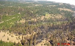
The fire created a mosaic within much of the mixed conifer forests by burning at varied intensities as fires did historically.
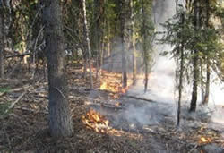
The Black Canyon and Wolf fires were started by lightning on August 7-8, 2008. Both ignitions were within the Black Canyon Wilderness and identified as appropriate candidates for Wildland Fire Use (WFU) based on the recently approved Ochoco Wildland Fire Use Plan. By August 17, the fires merged and became the Black Canyon Fire, expanding beyond the wilderness boundary. Fire growth was minimal after the fires merged due to a combination of precipitation, higher humidity, and management actions. Ultimately, the total size was 1,551 acres, with 849 acres in the wilderness, and all on National Forest.
The Ochoco National Forest Plan emphasizes a natural setting for the Black Canyon Wilderness, including lightning-caused fires. Wilderness benefits of the Black Canyon WFU include allowing fire to play its natural role within the Owl Creek drainage. The fire created a mosaic within much of the mixed conifer forests by burning at varied intensities as fires did historically. Mixed conifer and grand fir forest near Boeing Field burned more intensely than the rest of the fire area.
Primary Benefit
A reduction of surface and ladder fuels, limiting the potential for future fires to transition to hazardous high-intensity crown fires.
Lessons Learned
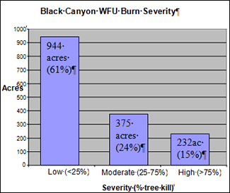
Although the amount of high burn severity is a relatively low percent of the total burn area, and it is within the context of the mixed fire regime of the area, it represents a loss of late structure habitat which is in limited supply on the Forest. Future application of WFU will attempt to minimize the loss of limited habitats while meeting other resource objectives.
For further information, contact Dave Owens at deowens@fs.fed.us or 541-416-6425.