

National Fire Plan Success Story
Prescribed Fire Reduces Fuels around Park Structures
Coronado National Memorial, Arizona
National Fire Plan - Fuels Reduction
2009
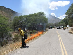
Hand ignition of prescribed fire using driptorch. NPS photo by Michelle Fidler.
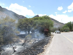
Objectives of the burn included reducing fine fuel loading and ladder fuels within the unit. NPS photo by Michelle Fidler.
On May 27, 2009, Coronado National Memorial conducted a prescribed burn to reduce fuels around park headquarters, park housing, the visitor center, and the picnic area. Objectives included reducing fine fuel loading and ladder fuels within the unit. Fuels in the area included grass, manzanita, oak, and juniper.
Eleven of fifteen planned acres were treated. Thunderstorm development mid-day caused unfavorable outflow winds so ignition was stopped and a checkline was constructed to hold the fire. Resources included 4 engines plus 15 firefighters from Saguaro National Park and Coronado National Forest.
This is the park’s second prescribed burn, part of a strategy to create fuelbreaks in the park that will help make wildfire easier to control if it occurs. The adjacent Coronado National Forest, Sierra Vista Ranger District previously conducted a prescribed burn in March 2008 that included a portion of the park. Firefighters also used chainsaws to thin around park structures in May 2008, further helping to create defensible space.
Wildfires are a concern in the park, especially due to limited egress and the potential for rapid fire spread within the steep, rocky terrain of the parks’ main topographical feature, Montezuma Canyon. To date, two major wildfires have affected the park: the Peak Fire in 1988 and the 103 Fire in 2006. Both fires burned significant acreage within the park and involved evacuations of park residents.
Coronado National Memorial encompasses approximately 4,750 acres in Cochise County, Arizona, along the United States/Mexico boundary. Elevations range from 5,000 to 7,825 feet. Vegetation is primarily desert grasses and shrubs at lower elevations and oak woodlands and pinyon/juniper forests at upper elevations. The area to the west and north of the memorial is administered by the Coronado National Forest, while most of the east boundary abuts Arizona State Trust land. Small amounts of private land are also adjacent to the northeastern and southeastern boundary. There is one narrow, mountain road through the park, only a portion of which is paved.
Contact: Kym Hall, Superintendent, (520) 366-5515 ext. 21.