

National Fire Plan Success Story
Community Assistance Program Lends a Hand in Treating Hazardous Fuels in South Dakota
Bureau of Land Management
National Fire Plan - Community Assistance
2009
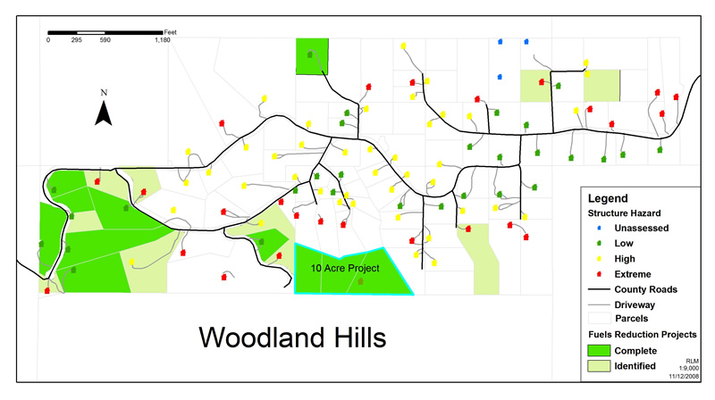
Woodland Hills project map. Photo by Randy Alexander, Landowner.
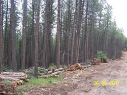
An area in Woodland Hills before fuels reduction treatment. Photo by Randy Alexander, Landowner.
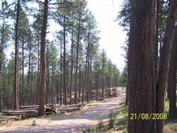
The same area in Woodland Hills after fuels reduction treatment. Photo by Randy Alexander, Landowner.
The community of Woodland Hills is located in Meade County, South Dakota. As its name suggests, the terrain is steep with canyons and limestone outcrops and is covered with ponderosa pine and some deciduous species. The Black Hills of South Dakota are notorious for their ability to produce quickly dense stands of ponderosa pine. The closed canopy and plenty of regeneration create the potential for serious catastrophic wildfire.
Three major wildfire events have occurred in this area in the last six years. Homes were either threatened or lost in all three fires. These fires ranged in size from 663 to 3,959 acres. A total of 7,726 acres have been consumed since 2002. Wildfires in past decades have also had detrimental effects on values in Meade County.
Community assistance programs, such as the one offered by the Bureau of Land Management to Meade County, have accomplished important work. This includes the assessment of existing conditions, public education, and hazardous fuels reduction programs, all of which are helping reduce rural communities’ wildfire risk.
The Woodland Hills community is working proactively to mitigate wildland fire. Ninety-seven homes have been surveyed for risk from wildfire. The team found that 35 were at extreme risk, 42 were at high risk, and 20 were at moderate or low risk from wildfire. Fuel loads, topography, and survivable space were the primary factors that determined the survey rating.
Nineteen fuel reduction projects were planned for Woodland Hills. Nine of them have been completed for a total of 38 acres. The hazard rating of eight homes has changed from extreme to low or moderate risk. In addition, the 38 treated acres have reduced the risk to this entire community by decreasing hazardous fuels. The Black Hills National Forest borders Woodland Hills on the south. Previous hazardous fuels treatments on the forest help protect Woodland Hills from that direction.
The most recent hazardous fuels reduction project in Woodland Hills was a 10-acre project that encompassed three separate parcels. The parcels are on the perimeter of the subdivision, which decreases any wildfire fire activity as it approaches structures or escapes from the community onto the national forest. As shown in the pre-treatment photo, the ponderosa stand in the particular parcel was incredibly dense, with a closed canopy and ladder fuels. The post-treatment photo shows a considerable decrease in the stand’s density.
In many rural areas, past fire suppression activities have allowed the build-up of hazardous fuels on private lands. Fuel reduction projects will not only help protect values in rural communities, but will substantially improve forest health. Successful projects, like the one in the Woodland Hills, will help provide public education and encourage private landowners to become proactive in reducing the threat from wildfire. These activities would not be possible without the community assistance program funding provided by the BLM.
Contact:
Rob Mattox, WUI Contractor
Black Hills Land Analysis
12007 Coyote Ridge Road
Deadwood, SD 57732
Office (605) 578-1556
Cell (605) 920-0255