

National Fire Plan Success Story
Horse Fire Successfully Managed For Resource Benefits
Zion National Park, Utah
National Fire Plan - Fuels Reduction
2009
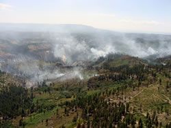
The Horse Fire burned through Ponderosa pine forest on the Horse Pasture Plateau.
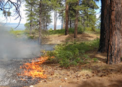
Fire behavior of the Horse Fire.
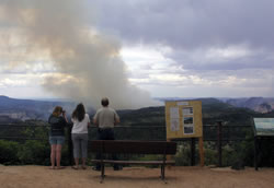
Visitors were able to observe the Horse Fire from Lava Point.
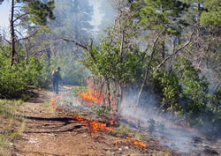
Firefighters burned out along the West Rim Trail.
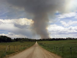
The smoke column from the Horse Fire was visible on some days.
During the summer season, most of the stories about wildfires are related to its destructive nature and the hardships faced by people in its path. While indeed, some wildfires are destructive and certainly warrant media attention for the human interest stories, numerous other wildfires that are successfully managed to provide benefits for our natural resources and help protect communities are overlooked by the press. A good example of one of these resource benefit fires was Zion National Park’s Horse Fire in July/August 2009.
The Horse Fire began on July 4 from a lightning storm that passed through the area. It was located on Horse Pasture Plateau, an area in the northern section of the park that receives a limited number of visitors.
Zion’s 2005 Fire Management Plan allows the park to manage naturally caused fires under a wide range of objectives, from full suppression to minimal interference. The choice of these options are based on many factors and fire and resource managers look closely at each naturally caused fire and decide the best method to manage the fire.
With the Horse Fire, many factors led to fire and resource managers deciding to manage the fire for resource benefit objectives. These included the fire’s location in an isolated area, no immediate threats to firefighter/public safety, natural or cultural resources, values at risk including private lands and structures, minimal issues from smoke impacts, forecasted weather conditions and the positive benefits to the fire-adapted ecosystem. Another key factor in the decision was the fact that the fire was surrounded on the critical downwind side by the park’s recently successful Three Finger Mesa Prescribed Burn in 2008 and the remaining sides by previous wildfires and cliff bands. These previously treated areas served their purpose as fuel buffer zones to the Horse Fire because of reduced amounts of fuels and lessened the chance that the fire would exceed management capabilities. The chosen strategy allowed the park to let the fire perform its natural role in the ponderosa pine forest.
The fire was managed under a local Type III incident command organization, utilizing incident commanders from both the park and Dixie National Forest. At various times, different groups of firefighters were brought in to help with the management of the fire. This included wildland fire modules, Hot Shot crews, park staff and other local firefighting and management resources. Firefighters burned out along the West Rim Trail to strengthen the main holding line and constructed firelines to contain the fire to its pre-determined management area. The fire was also monitored daily by the park’s resource and fire management staff to ensure that resource objectives were being met.
The Horse Fire eventually burned over 2,100 acres until it was officially declared out on September 25, 2009. Fire behavior ranged from moderate to light, depending on the weather conditions and the fuels encountered by the fire. On a few of the active fire days, smoke columns could be seen from quite a distance from the park. Isolated smokes from the fire were visible for weeks from the Lava Point area but impacts to park visitors and local residents were very minimal.
Information and education played an important role in the successful management of the fire. Fire updates were sent out on a daily basis to the media as well as to other interested parties. The park’s website and the National Park Service’s NPS Fire & Aviation website were also used to post daily information, photos and maps. The fire could easily be seen from Lava Point, a viewpoint in the park frequented by many visitors as well as local residents. An information bulletin board was set up there and updated daily. During times of active fire behavior and during most weekends, information officers were at the viewpoint to talk to the public and also serve as fire monitors. This served as a perfect opportunity for the visitors to safely view a fire and to be educated as to the reasons why Zion fire managers chose to manage the fire for resource benefit.
By actively managing fire such as the Horse Fire and conducting prescribed burns such as the Three Finger Mesa, land management agencies, including the National Park Service, are taking proactive steps to reduce the risk to the public and firefighters as well as properly managing lands in their care.
Contact: David Eaker, Fire Communication and Education Specialist, (435) 772-7811.