
National Cohesive Wildland Fire Management Strategy Success Story
Lower Fire Managed Across Boundary as an Interagency Incident
Grand Canyon National Park, Arizona
Cohesive Strategy - Response to Wildfire
2011
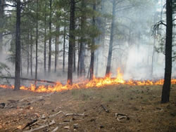
Lower Fire, September 3.
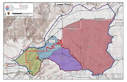
Lower Fire Map, September 9, 2011.
The lightning-caused Lower Fire was discovered in Grand Canyon National Park on August 19, 2011. The fire was located about 12 miles southeast of Grand Canyon Village, approximately 1½ miles south of Moran Point, ¾ mile southeast of Desert View Drive (also known as Highway 64), and ½ mile north and west of the park/forest boundary.
The fire was initally smoldering and creeping along the forest floor, and burning some heavier fuels like downed logs. It was moving slowly eastward through pine litter and needle cast in open ponderosa pine forest with some patches of pinyon-juniper. National Park Service (NPS) and US Forest Service (USFS) fire managers on the South Rim of the Grand Canyon evaluated the fire’s potential growth and decided to cooperatively manage the Lower Fire for both resource and protection objectives within both Grand Canyon National Park and the Tusayan District of the Kaibab National Forest.
Resource objectives for the fire included returning fire to a fire-adapted ecosystem and recycling of forest nutrients in order to maintain forest health. Protection objectives for the fire included protection of sensitive cultural resources, Hull Cabin, and the Arizona Public Service (APS) power line corridor.
Firefighters initially monitored the fire's growth. Fire activity increased gradually over the next few days with the return of warmer, drier conditions. Fire behavior included low intensity surface fire with occasional individual and group tree torching.
At the same time fire managers surveyed and assessed cultural, historical, and heritage resources in the area. They then prepared resources near the fire perimeter, like the Hull Cabin, by creating defensible space around them or wrapping them with a fire-resistant aluminum material that reflects heat to help protect them in the event the fire burns around them.
On August 31, the fire progressed across the park/forest boundary. When conditions were favorable, firefighters implemented ignitions on National Forest lands to prevent fire spread outside of the planning area and to protect sensitive cultural resources. Fire behavior consisted of low intensity surface fire with occasional individual and group tree torching. The low intensity fire was ideal for meeting management objectives of returning fire to a fire-adapted ecosystem, improving wildlife habitat and recycling forest nutrients, while protecting sensitive cultural resources within the fire area.
Fire crews completed ignitions on National Forest lands within the Lower Fire planning area on September 8. As a result of these activities, the fire grew to 1,787 acres. Fire activity then moderated with an increase in moisture.
On October 12, following a warm drying trend throughout the region, an active flame front was observed on the northwest flank of the fire. Further scouting of the potential fire area indicated approximately 300 acres of consistent ponderosa fuels adjacent to the active portion of the fire and management staff moved to active monitoring of the fire. Ignitions were initiated on October 17 along a utility corridor north of the fire on National Park Service lands in order to protect APS power lines and water lines. The fire merged with the burnout the following day. The fire continued to move east and west in the widespread ponderosa litter over the next three weeks, exhibiting flanking and creeping behavior with limited occurrences of small tree torching in dog hair thickets.
No additional ignitions occurred after October 17 however fire crews continued to patrol the perimeter. Minimal perimeter growth occurred on National Park Service lands as the fuels continued to burn until repeated rain and snow extinguished all flames.
On November 9, westward progress of the Lower Fire stopped when it reached an area that had burned during the 2010 Buggeln Prescribed Fire. Fire spread to the east was halted by a transition from ponderosa to pinyon-juniper dominant areas and a lack of ground fuel. The fire was contained to the north and south by the ignitions that had been conducted along the APS utility and on the Kaibab National Forest. The fire was declared “out” on December 5.
The final size of the Lower Fire was approximaly 2,002 acres with an estimated 282 acres located within Grand Canyon National Park and the rest located on the Kaibab National Forest.
By working together to manage the Lower Fire rather than focusing on jurisdictional boundaries, NPS and USFS fire managers had a greater opportunity to manage fire across the landscape in order to meet forest health objectives. As a result, the Lower Fire played a positive role in maintaining and restoring the natural range of variability of the ecological community within the planning area. Additionally, crews were able to be proactive in protecting cultural resources and wildlife activity areas during the management of the fire.
Contact
Daniel Pearson, South Rim Assistant Fire Management Officer
Email: Daniel_Pearson@nps.gov
Phone: (928) 638-7934
Keywords: Partnerships, Fire Ecology and Restoration