
National Cohesive Wildland Fire Management Strategy Success Story
Minimizing Fireline Suppression Impacts to Park Resources
Big Thicket National Preserve, Texas
Cohesive Strategy - Response to Wildfire
2011
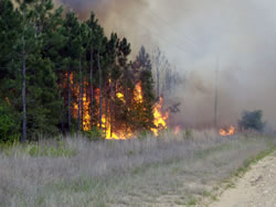
Pipeline Fire burning on private land during initial attack 4/16/11. NPS photo.
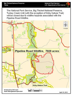
Pipeline Fire map.
The Pipeline Road Fire started on private land on April 16, 2011, approximately 10 miles northeast of Kountze, Texas. Critical fire weather of low relative humidity and high winds resulted in extreme fire activity of crowning, torching and running. The fire burned actively through the night. A wind shift the following morning pushed the fire into Big Thicket National Preserve.
Approximately 652 acres of the Pipeline Road Fire burned in Big Thicket National Preserve. Dozer lines were constructed in the preserve to stop the fire from spreading onto private property and protect structures. Firefighters used natural barriers to contain a large spot fire and conducted a burnout operation on April 19, increasing the fire’s acreage. The fire continued burning in the interior of the perimeter for several weeks.
Precipitation on the evening of April 25 significantly aided in suppression efforts. The Texas Forest Service reported the Pipeline Road Fire was contained on April 27 at approximately 7,100 acres. Following the fire, fire ecology and restoration efforts were undertaken. Control lines were rehabilitated, and fire effects monitors installed photo points to monitor fireline rehabilation and resource impacts.
The Turkey Creek Unit was temporarily closed during the fire, however most of the area reopened on April 29. As of August 2011, the middle section of the trail from the Sandhill Loop north to the Hester Bridge remained closed until eight burned boardwalks can be repaired. The closed portion of the trail is expected to be reopened in Fall 2011.
Cooperators included the Texas Forest Service, local volunteer fire departments, the U.S. Forest Service, Bureau of Land Management, and Bureau of Indian Affairs.
Contact
Fulton Jeansonne, Fire Management Officer
Email: Fulton_Jeansonne@nps.gov
Phone: (409) 951-6850
Keywords: Fire Ecology and Restoration