
National Cohesive Wildland Fire Management Strategy Success Story
Multi-year Project Culminates in Safer Community
Grand Teton National Park, Wyoming
Cohesive Strategy - Fire-Adapted Communities
2011
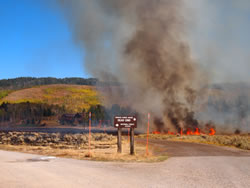
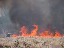
Fire crews burn sage and grass during the Shadow Mountain Prescribed Fire on the east boundary of Grand Teton National Park. The homes are located between the boundary of the Park and Bridger-Teton National Forest.
During fall 2011, Teton Interagency fire crews completed a multi-year project to help Shadow Mountain become a more fire-adapted community. The project started in 2009 when Student Conservation Association (SCA) youth volunteers conducted risk assessments on 21 private structures and interagency crews performed a 22-acre mechanical fuels reduction. The project culminated in a46-acre prescribed fire on Sept. 21, 2011.
The small community of Shadow Mountain is nestled between Grand Teton National Park to the west and the Bridger-Teton National Forest to the east. Sagebrush and grass fuels on the valley floor border the private property that is surrounded by aspen and timbered conifer islands. The residents are no strangers to wildfire - since 1965, 50 wildfires have burned within 3 miles of Shadow Mountain, the largest of which were the 5,440-acre Hunter Fire in 1988 and the 3,439-acre Row Fire in 1994.
The Youth Conservation Program (YCP) spent a week working with the Teton Interagency Fuels and Engine 3 crews to complete the mechanical aspect of the project. The two SCAs were involved with the YCP crew project days, which allowed them to implement fuels treatment on park land that reflected the recommendations they had given homeowners.
Based on the Teton County Wildfire Protection Plan, the Shadow Mountain area is one of the priority wildland-urban interface areas in the county. The prescribed fire provided an important fuel break from future wildfires that could threaten the developed area.
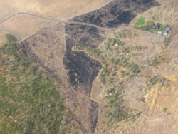
An immediate post-fire aerial photo shows the severity of the burn in relation to the homes in the interface. This photo was one of several used to create the burn severity map in the follwoing picture.
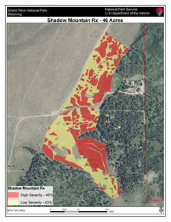
Burn severity map.
Burn boss trainee Wayne Petsch said the prescribed fire treated the last portion of federal ground in the area that hadn’t been burned or mechanically treated since the early 1990s.
“One of the objectives was to reduce the sagebrush which is very resistant to fire suppression, to grass, which has faster moving fires but they are easier to control with water and engine operations,” Petsch said. “Post-treatment monitoring shows we met our objectives, with the highest severity burn being closest to structures.”
Immediately after the fire, the Teton Interagency Helitack crew conducted an aerial flight of the burn unit (see photos). The fire effects monitor’s report stated: “It is noteworthy that the largest concentration of high severity was nearest the homes. This bodes well for the long term reduction in potential fire intensity near the homes, should a wildfire occur.
Also as part of the post-burn monitoring, the fire effects crew will map and track the spread of any invasive species, including cheatgrass, thistle, and smooth brome (Bromus inermis) in the burn unit. They will coordinate efforts with Grand Teton’s Invasive Species Program to eliminate any infestations.
Contact: Traci Weaver, Fire Education, traci_weaver@nps.gov, (307)739-3692.
Keywords: Youth Involvement, Volunteerism