
National Cohesive Wildland Fire Management Strategy Success Story
Bringing Fire Back into the Ecosystem
Grand Teton National Park, Wyoming
Cohesive Strategy - Maintain and Restore Landscapes
2011
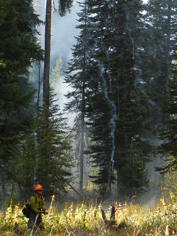
Firefighter Josh Fain watches for spot fires as embers rain down during the Phelps Moraine Prescribed Fire Sept. 29, 2011.
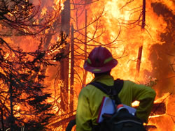
Burn Boss Trainee Jon White observes a hot pocket of firs and deadfall burn during the prescribed fire.
Fire management in Grand Teton National Park took an important step toward re-introducing fire to the ecosystem when they completed the 84-acre Phelps Moraine Prescribed Fire on Oct. 2, 2011. The primary fire management goal for the park is to allow the natural process of fire to exist within the park while protecting lives and property. The mixed conifer dominated Phelps Moraine project area was selected due to its location between values at risk and wild areas.
Since 1960, lightning has ignited eight wildfires in the 1,300-acre Phelps Moraine area in the southern end of Grand Teton National Park, but none grew larger than a tenth of an acre. Park managers chose to aggressively suppress those fires because of the potential for them to spread toward developed areas, including private residences, which resulted in missed opportunities to allow fire to play its natural role. The intent of the Phelps Moraine burn was to reduce burnable live and dead vegetation ahead of where a fire would likely spread. The burn, combined with a previously completed mechanical treatment project, created a buffer between future wildfires and developed areas, which should provide higher confidence and more flexibility in managing naturally ignited fires in the future.
To implement the park’s 2004 fire management plan, staff analyzed areas where lightning fires typically are suppressed within the park’s conditional fire management zone. They then divided the areas into management blocks based on existing or potential fire spread barriers. Using the latest technology in fire modeling, FlamMap’s Minimum Travel Time and flow path, managers were able to locate and propose projects that would modify fuels in areas where most fires are predicted to move. This would in turn allow managers more latitude in accepting fires within the conditional fire management zone.
The Phelps Moraine project was a long time in the making, starting first with a 30-acre mechanical treatment along the Death Canyon Trailhead Road. Crews completed that project and burned the subsequent piles during the late fall of 2009. In the summer of 2010, resource management raised a concern about invasive weeds in the area slated for prescribed fire. After extensive cooperative weed mapping by fire and vegetation crews, the proposed burn area was revised to 84 acres, down from the original 482 acres. During a test fire later that fall, fire managers decided to postpone the burn due to concerns it would burn too hot and kill more of the overstory trees than desired. The park revisited the objectives and conducted burn entry in 2011 that completed this phase of the project.
“Part of the collaboration success with Science and Resource Management was having them recognize the challenges of meeting large-scale project objectives as constraints made the project smaller and smaller,” said Burn Boss Mack McFarland. “They realized that it was unrealistic to try to meet all of the very specific fire mosaic objectives developed for the larger project area when only burning 84 acres of continuous fuels. Science and Resource Management had concerns with the project but they were willing to support this small treatment in an effort to learn more about weed response in the burned area and to increase the chances of natural fire to affect a larger landscape in the future.”
To safely and effectively conduct the prescribed fire, fire crews used a low-impact control line along the interior of the burn unit. Rather than digging fireline, they used a natural barrier of the creek to minimize impact and provide for safe access for ignition and holding resources.
“Although it was a relatively small burn, we took our time, burning it slowly and deliberately to achieve our objectives safely,” McFarland said. “From a fire ecology and restoration standpoint, we made great strides in allowing the return of natural fire in this Treasured Landscape.”
Contact: Traci Weaver, Fire Education, traci_weaver@nps.gov, (307)739-3692.
Keywords: Fire Ecology and Restoration, Treasured Landscapes