
National Cohesive Wildland Fire Management Strategy Success Story
Big Cypress Firefighters Develop Successful Plan for Prioritizing and Treating Hazardous Fuels
Big Cypress National Preserve, Florida
Cohesive Strategy - Maintain and Restore Resilient Landscapes
2012
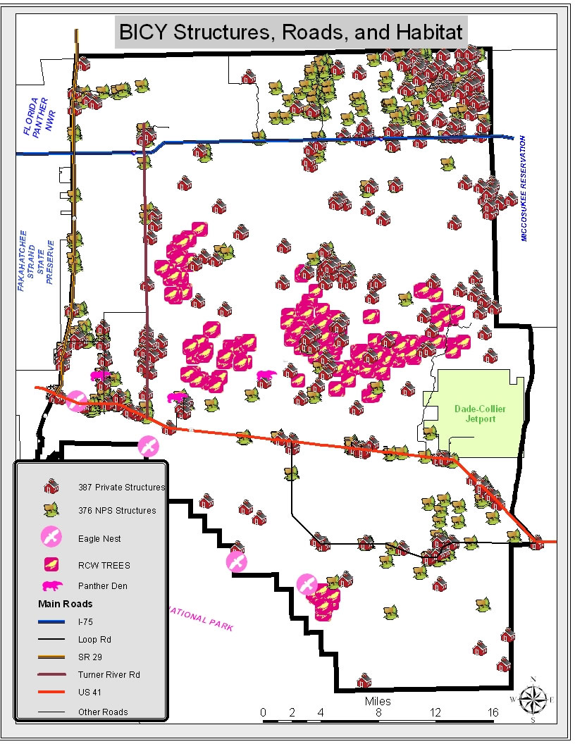
Figure 1 - Habitat and Wildland Urban Interface.
For the 2011-2012 prescribed fire season, National Park Service wildland firefighters at Big Cypress National Preserve (BICY) developed a new plan to prioritize hazardous fuel reduction treatments through the application of prescribed fire.
In line with National Park Service Director’s Order 18, the Big Cypress Fire and Aviation Management plan specifically based a high priority for fuels treatments on two of the National Park Service’s wildland fire management mission goals: Protection of Values through Effective Risk Management and Restore and Maintain Fire-Adapted Ecosystems.
Prioritizing fuels treatments that provide the most benefit to the park as well as the community, sometimes causes a conflict as these two mission goals often overlap across the landscape at Big Cypress National Preserve. How can fire managers simultaneously protect life and property while maintaining and protecting the Preserve’s diverse ecosystem and habitat? What is the best way to prioritize fuels treatments to accomplish these goals?
In an effort to solve this dilemma, BICY firefighters created a process that would help them visualize and prioritize fuels treatment objectives that would protect and sustain infrastructure, private and government property, and ecosystems, including threatened and endangered species habitat.
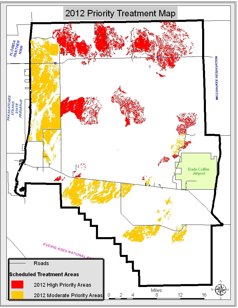
Figure 2 - The red areas indicate that the criteria has been met for an area that has not burned in five or more years, and contain pine or prairie fuels that lie adjacent to a value at risk (roadways, structures, etc.) located within a half of a mile to its location. The orange areas indicate a moderate or lower priority area for 2012.
Using three main weighted criteria of fire return interval, fuel type, and distance that roads and structures are from the other two criteria, firefighters created a prioritization map (see Figure 2).
Fire return interval is the time in years between fire events. Fire return interval is important because the longer the departure from natural cycles of fire, which is typically 3-5 years, the more severe the wildfires and fire behavior will be. Threatened and endangered species habitats such as the Florida panther and red-cockaded woodpecker require shorter fire return intervals to maintain viable habitat. Under this interval of fire occurrence in these ecosystems, fires will burn with less intensity, thus increasing sustainability rates and survivability of species, and will also aid firefighters in controlling wildfires.
Fuel type must be evaluated because fire behavior and fire intensity changes depending upon the type of fuel in which the fire is burning. In southern Florida, the pinelands with a palmetto understory burn most actively. The prairies also burn very readily but are easier for firefighters to extinguish than pinelands.
The distance that a structure or road is from the previously described fuel types, with a higher fire return interval, can have a greater impact on roads, structures, habitat, and public and firefighter safety. For example, the closer that a road or structure is to a pineland that has not burned in seven years; the greater is the risk to the public and firefighters. Primarily, smoke impacts to highways could cause road closures or accidents. The closer the proximity to these structures means there is even less time for firefighters to respond and try to extinguish the fire. Fire behavior and fire spread rates that cannot be contained quickly by firefighters could result in damaged or destroyed property.
Areas are defined as being “high priority” if they have not burned for longer than five years, lie less than half a mile to the nearest structure or road, and were located within or adjacent to pinelands and prairies. Areas meeting these criteria were identified as requiring immediate treatment (Figure 2: Red Areas).
In contrast, areas that had been burned recently (five years or less), farther from roads and structures (more than half of a mile), and in varying fuel types (pine, prairie, cypress, or hardwood hammocks) were defined as “moderate or lower priority” treatment areas (Figure 2: Orange Areas).
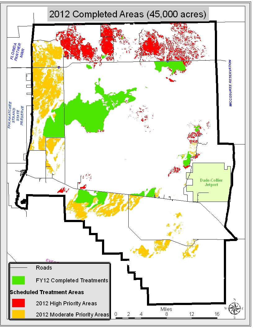
Figure 3 - Areas in the Fiscal Year 2012 treatment area that were completed and scheduled by April 2, 2012.
Each year, progress toward desired conditions will be reassessed, and fire staff will generate a new map. Under normal projected conditions, the map will never be the same, as wildfires, prescribed fires, and uncompleted projects will have an immediate effect on proposed treatment areas for the next year. The map must be updated annually to make certain that no areas with burnable vegetation, structures, or roads will be overlooked.
In November 2011, the fire crew at Big Cypress National Preserve began implementing the Priority Treatment plan. As of April 2, 2012 approximately 45,000 acres have been treated (Figure 3). The areas remaining in red would be a good representation of the high priority targets for FY 2013 if burning ceased on April 2, 2012, when this map was produced.
Figure 4 shows a representation before and after of the treated and untreated areas side-by-side. The picture on the left shows pre-treatment before 2009, or what the Preserve’s high priority areas would have looked like without prescribed fire or wildfire treatments. The picture on the right shows post-treatment from 2009 to 2012 including natural wildfires. Currently, a fuels treatment plan is being written for the northeast corner of the preserve and implementation of that plan will begin in 2013.
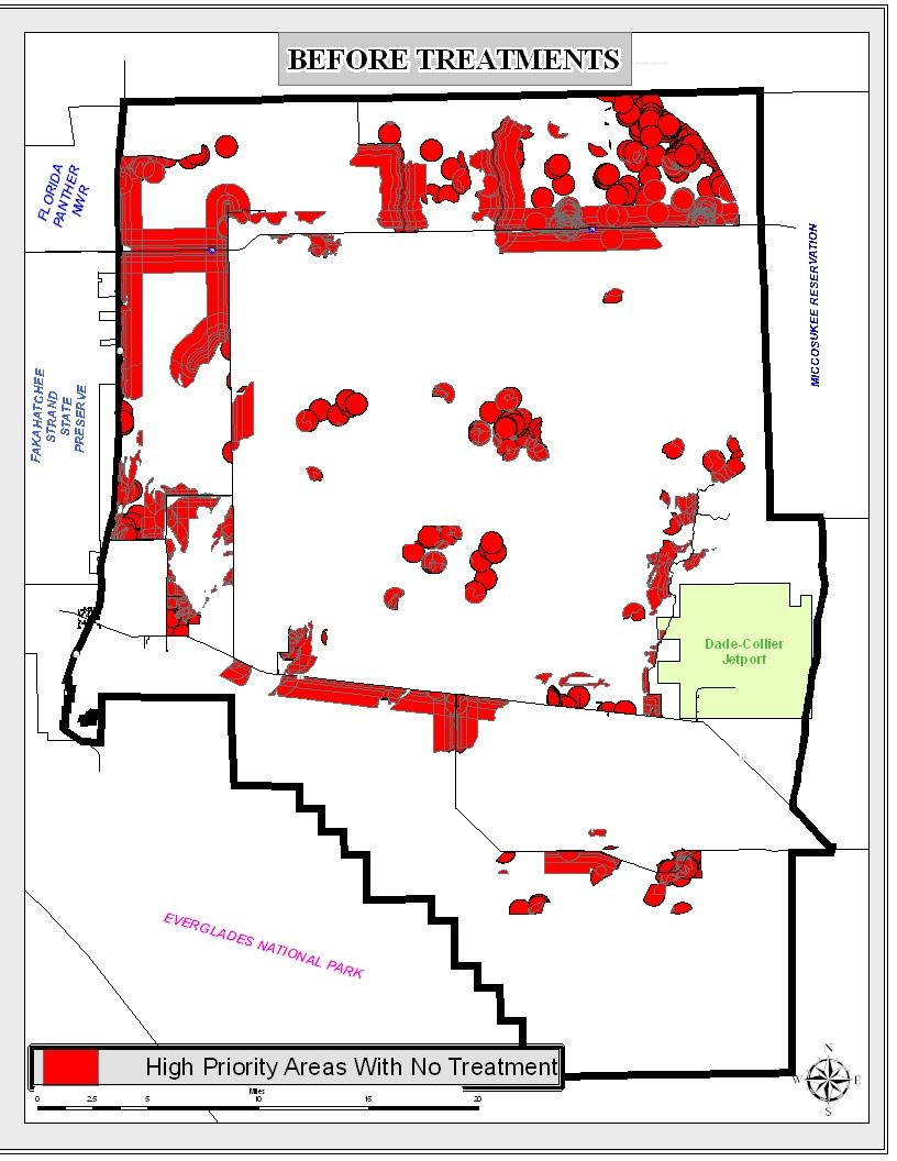
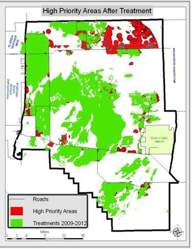
Figure 4 - Comparison of Pre-treatment and Post-treatment areas. Left: High priority areas in 2008 before treatments. Right: 2009 - 2012 treatments.
The results of a successful planning and implementation effort.
The Big Cypress National Preserve fire crew plans to treat all burnable vegetation on the Preserve on a five to seven year rotation using the methods previously described. This fuels treatment plan will simultaneously protect life and property while maintaining and protecting the Preserve’s diverse ecosystem and habitat, by replicating the natural fire return interval in the more volatile fuel types that are in close proximity to structures and roads.
Contributors: Jill Waisley, Jay Thatcher, Mindy Wright, Adam Kunce.
Contact: Justin Turnbo, Prescribed Fire Specialist, Big Cypress National Preserve, Justin_Turnbo@nps.gov, 239-695-9280 ext 108.