
National Cohesive Wildland Fire Management Strategy Success Story
Interagency Suppression of Horse Canyon Fire
Carlsbad Caverns National Park, New Mexico
Cohesive Strategy – Response to Wildfires
2012
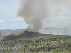
Horse Canyon Fire, 5:00 pm, July 1, 2012.
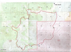
Horse Canyon Fire map.
Personnel on the Lincoln National Forest who immediately responded and engaged in suppression activities discovered the Horse Canyon Fire on Friday, June 29, 2012. The fire was located approximately 3 ¼ miles southeast of Queen, NM in piñon, juniper, grass, and brush. The next day, the fire crossed into Carlsbad Caverns National Park and by 2:30 pm on Sunday, June 30, the Pecos Zone Type III Team took over management of the fire.
The fire burned in an area with limited vehicle access due to steep rugged terrain leading to use of indirect tactics to suppress the fire. Firefighters used a burnout operation to tie the fire into a fire scar from the 2011 Serpentine Fire. Helicopters and air tankers assisted ground resources with bucket drops and retardant along the fire perimeter to keep the fire from crossing containment lines. Fire crews also utilized existing roads and trails to help keep the fire in check. Multiple burnout operations were completed to tie in and strengthen containment lines. Point source protection included a communications site for Carlsbad Caverns National Park. Other values at risk included the watershed, grazing lands, livestock, and water supply lines.
Cooler temperatures, higher humidity and rain showers helped with containment efforts. The majority of crews were released to support other incidents. Remaining resources continued to patrol and monitor the fire perimeter looking for lingering smokes and hotspots. The Pecos Zone Type III Team turned the fire back over to the local district on July 6. Through efficient collaboration, the fire was contained at 7,287 acres on July 7. Partners included the Bureau of Land Management, National Park Service, USDA Forest Service, Eddy County Emergency Management, and New Mexico State Forestry.
Contact: John Montoya, Fire Management Officer, John_Montoya@nps.gov, (915) 828 - 3251 ext. 217
Keywords: Cost Effectiveness and Efficiencies, Partnerships