

National Fire Plan Success Story
The Chemult Fire, Effective WUI / Fuel Treatments
Chemult Ranger District,
Fremont-Winema National Forests, Oregon
National Fire Plan - Fuels Reduction
July 2006
On July 8th 2006 at approximately 1750 hours a thunder cell produced two negative down strikes with no precipitation on the northern edge of the community of Chemult Oregon, One of the down strikes started a fire on the east side of Highway 97 approximately 1,200 feet northeast of the Chemult Ranger station. The fire was named the Chemult Fire.
The District Duty Officer and one Initial Attack Engine crew from the Chemult Ranger District were on scene within three minutes of the fire being detected. The fire had already grown to one acre in size. The fire was located between two sets of railroad tracks which made access difficult but provided fuel breaks on the east and west sides.
Weather data from the Hoyt Remote Automated Weather Station (RAWS) which is located 25 miles southeast of the Chemult Fire was as follows:
- 1300 hrs. Energy Release Component - 50 (considered High Fire Danger in the Pumice block)
- 1600 hrs. Temperature 90 degrees. Relative Humidity 12%. Southeast wind (20 foot) 4 mph.
- 1800 hrs. Temperature 76 degrees. Relative Humidity 29%. Wind calm.
During the first hour the eye level winds on the fire were 3-8 mph. with vairiable directions. A thunder cell was just north of the fire which caused the variable wind speed and direction.
The Chemult Fire started in the Blaze Timber Sale, one of three timber sales designed to reduce the fire hazard around the town of Chemult. The Blaze Timber Sale was still active so the fuel treatments of commercial thin, pre-commercial thin, grapple pile, and pile burn had not yet been completed.
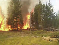
The Chemult Fire started in light slash (FM-11) with pockets of dead and down lodgepole pine. The pockets of dead and down lodgepole pine are common around the community of Chemult and are from the mountain pine beetle epidemic that occurred in Central Oregon in the mid 1980s. The commercial material had been removed but the understory was fairly dense with little if any spacing between the tree crowns. The surface fuels produced flame lengths of 6 to 8 feet with significant torching which in turn created heavy short and moderate range spotting of up to 800 feet.
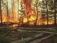
Chemult Fire burning in pockets of dead and down lodgepole pine.
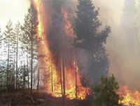
Chemult Fire - flame lengths of 6 to 8 feet.
This photo was taken approximately 20 minutes after detection as the fire hit the western railroad right-of-way.
The photograph to the right is approximately 20 minutes after detection as the fire hit the western railroad right-of-way approximately 300 feet west of the point of origin. The right-of-way stopped the main fires spread to the west but tree torching produced 30-35 spot fires on the west side of the tracks between Highway 97 and the tracks, a distance of 300 - 400 feet, and two spot fires across Highway 97. The first of these spots was approximately 600 feet from the main fire and the second was approximately 800 feet. These spots ignited in units that had been pre-commercial thinned to a 20 X 20 foot spacing. The thinning slash and natural fuels had been grapple piled and the piles were burned in 2004. These treatments kept the spots from growing as the largest one was 8 X 10 feet.
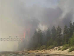
When the fire hit the right-of-way to the west, a wind shift produced by the nearby thunder cell pushed the fire to the south towards the community of Chemult with a spread rate of approximately 10-12 chains per hour with short runs through the tree canopy. The fire traveled 500 to 600 feet to the south and entered a unit that had been thinned to a 20 X 20 foot spacing. The slash had been hand piled and the piles were burned in 2004. When the fire entered this unit it dropped to the ground and the flame lengths and spread rate were significantely reduced and initial attack resources were able to construct and hold the control lines. The next two photographs are pictures of the Chemult Fire as it entered the unit located on the south side of the fire.
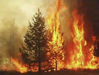
Chemult Fire as it entered the unit located on the south side of the fire.
Chemult Fire as it entered the unit located on the south side of the fire.
The final size of the fire was three acres and required: one load of retardant from a Type I Air Tanker, two dozers, one 20-person crew, five engines, and two water tenders to control.
The fuel treatments that occurred in this area are a direct result of the National Fire Plan and would not have occurred without the emphasis on Wildland Urban Interface. There is no doubt that these treatments had a significant impact on the outcome of this fire. Without these treatments the Chemult Fire would have spread to both sides of Highway 97 and the push to the south would have seriously threatened the Chemult Ranger Station and administrative site as well as the community of Chemult.
George M Libercajt
District Fire Management Officer
Chemult Ranger District
Fremont-Winema National Forests