

National Fire Plan Success Story
Evaluating the Influence of Landscape Attributes and Burn History On Fire Severity in The Klamath Mountains
Klamath National Forest
National Fire Plan - Firefighting
2007
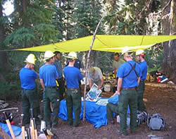
Training fire crew to sample fire severity.
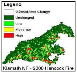
Example of a calibrated fire severity map, Hancock Fire.
Project Description
The Klamath National Forest, Pacific Southwest Research Station, and Region 5 Ecology Program monitored vegetation based fire severity for the 2006 fires in the Klamath Mountains, California. We sampled 100 field plots across five large fires (greater than 1000 acres) in the summer of 2007, using both the Composite Burn Index (CBI) and more explicit measurements of fire effects to stand structure and survival. The field data allow for validation (accuracy assessment) and calibration of fire severity measurements ("RdNBR") made from LANDSAT remotely sensed imagery.
Our overall purpose is to investigate the roles played by landscape attributes (e.g., slope, aspect, slope position) and other variables (e.g., vegetation type, time since last burn, fuel moisture) in driving spatial patterns of fire severity. We are also interested in developing a more quantitative alternative to (or version of) the CBI. This project responds directly to management needs, and products and procedures developed should prove valuable to managers before and after future fires.
A predictive model of fire severity could help fire managers and Forest line officers to plan appropriate management response to fires in actively managed landscapes as well as wilderness settings. This information could help to reduce costs of fighting fire. Our fire severity data can also be used to (1) calibrate fire behavior and effects modeling, (2) carry out post¬fire updates to vegetation layers, and (3) address a variety of specific resource questions.
Implementation Plan and Accomplishment To Date
We plan to finish data analysis over the winter and complete a manuscript describing our findings by the end of the summer, 2008. As fires occur in the Klamath Mountains, we will continue to collect fire severity data, based on funding and field crew availability. Eric Knapp and Carl Skinner of the PSW-Research Station are the lead researchers on this project.
| Fire Name | Start Date | Control Date | Unchanged Acres | Low Acres | Moderate Acres | High Acres | Total |
|---|---|---|---|---|---|---|---|
| Somes | 24Jul | Nov. 8 | 5697 |
9192 |
565 |
170 |
15,624 |
| Titus | 23Jul | Sept. 24 | 1176 |
2934 |
1219 |
943 |
6,272 |
| Hancock | 23Jul | Oct. 23 | 10440 |
8499 |
2187 |
1044 |
22,170 |
| Rush | 23Jul | Oct. 2 | 808 |
3317 |
758 |
257 |
5,140 |
| Uncles | 23Jul | Oct. 23 | 3454 |
7744 |
3752 |
2699 |
17,649 |
| Total | 21,575 |
31,686 |
8,481 |
5,113 |
66,855 |
Contacts
- Clint Isbell, Fire Ecologist, Klamath National Forest. 5308414510; cisbell@fs.fed.us.
- Max Creasy, Northern California Province Ecologist, USDAForest Service Region 5 Ecology Program. 5308414432; mcreasy@fs.fed.us.
- Eric Knapp, Pacific Southwest Research Station, Redding Lab. 5302262555; eknapp@fs.fed.us.
- Jay Miller, Remote Sensing Specialist; Fire, Fuels and Aviation Mgmt. 9166401063; jaymiller@fs.fed.us.