

National Fire Plan Success Story
Gasquet Community Protection Project
Smith River National Recreation Area, Six Rivers National Forest
National Fire Plan - Fuels Reduction
2007
The Smith River National Recreation Area, Six Rivers National Forest, implemented the Gasquet Community Protection Project (GCPP), which cut moderate to heavy brush, seedlings, and saplings, and limbed lower tree branches in order to create shaded fuel breaks in six areas adjacent to the Gasquet Community. These fuel breaks may provide additional wildfire protection for the community. The six GCPP areas are near Pioneer Village (18 acres), North Fork Loop (27 acres), Gasquet Mobile Home Park (23 acres), French Hill Road (61 acres), on Gasquet Mountain Road (100 acres), and along French Hill Trail (300 acres).
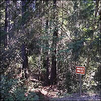
Before treatment
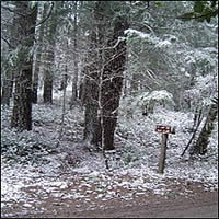
After treatment
Implementation of four areas began in August 2003, with remaining areas starting shortly after. All treatment areas are designed to reduce hazard fuels on National Forest Service System (NFS) lands to assist firefighters in protecting structures and improvements in the event of a wildfire. Treatment of GCPP was finished in spring 2007. Follow up maintenance will occur as needed.
Vegetation on NFS lands in these areas was contiguous with overstocked trees and brush, creating resistance to control in the event of a wildland fire. The project area is adjacent to the US Hwy. 199 corridor where the threat of human-caused fires is great. Residential homes and other improvements exist within 100 feet of Forest Service managed and protected lands. GCPP was designed to treat fuels incrementally within 300-500 feet of private land boundaries and major trail and road systems adjacent to the Gasquet community. In 2006, the Del Norte Fire Safe Council applied for and received a National Fire Plan grant to treat private lands in conjunction with the GCPP. All private land treatment was also complete in spring 2007. Creating shaded fuel breaks on NFS and private lands will provide additional defensible space and assist with control efforts in the event of a wildland fire threatening private property within the town Gasquet.
In August of 2001, Gasquet, California was listed in the Federal Register (Vol. 66, No. 160) as an urban wildland interface community that is at high risk from wildfire, which identifies the community of Gasquet as a priority fuels treatment under the National Fire Plan. In addition, the North Fork of the Smith River Watershed, adjacent to and directly north of Gasquet, is a municipal watershed which is also emphasized for protection within the core principles of the Western Governor's 10-Year Comprehensive Strategy (August 2001).
Contact: Sheila Balent or Syndy Zerr at (707) 457-3131