

National Fire Plan Success Story
New Fire Station Benefits Parks
Sequoia & Kings Canyon National Parks, California
National Fire Plan - Community Assistance
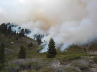
The Highbridge East Prescribed Fire in Fall 2005.
In 1995, the Mineral King area of Sequoia National Park was selected as a study site to experiment with reducing the risk of wildfires across an entire landscape. Known as the Mineral King Risk Reduction Project (MKRRP), fire managers set a plan in motion to strategically use prescribed fire and mechanical thinning to protect local communities and restore fire's natural role in the environment.
Now, twelve years later in 2007, the parks have finished 22 prescribed fires and at least a half dozen mechanical fuel reduction projects in the Mineral King area for a total of approximately 11,500 acres.
"It takes a huge amount of team work to pull off a project of this scale," said David Allen, Sequoia District Fire Management Officer. "In order to achieve our goals, we needed specialists from all disciplines - like fire managers, fire ecologists, and educators - to work together with members of the local communities."
The 50,000-acre East Fork Kaweah River drainage was chosen as the project site because of the serious risks for an unplanned wildfire threatening the small communities of Silver City and Mineral King. These communities, which are situated in a heavily forested area, have only one access road. A wildfire could easily block off this escape route thus endangering homes, businesses, and park visitors.
The first step in this long-term project involved piecing together an accurate picture of the area's fire history. Scientists studied tree rings to determine the natural historic pattern of fires in the drainage. Fire scars on these tree rings showed that at least 327 fires had occurred between 1400 and 1995 AD in forests covering 31,300 acres of the watershed.
On low-to-mid-elevation north slopes where cooler, damper conditions exist, fires occurred approximately every 21 years with large fires occurring during the driest years. At similar elevations on south facing slopes, fire return intervals were more frequent, about once in every 9 years with fires generally occurring regardless of how wet or dry the year was. With these frequent fires, fuels did not build up to unnatural levels. But, as Euroamericans settled in the area, the natural fire cycle was dramatically interrupted and fuels began to accumulate. While large-scale fires were recorded in the tree-ring record in the past, no large fires had occurred in the drainage since 1889.
With all this information, fire managers had a difficult task in front of them. How could they develop a burning program that could be done safely with very high fuel loadings on the ground? They started by creating a map of burn units that built one off the other, like puzzle pieces. If done successfully, each burn would create better conditions to complete the next one. In some cases, mechanical fuel reduction projects were planned first. For example, three mechanical projects that began in 2002 set the stage for the most recent burn, the Silver Prescribed Fire in fall 2006.
Prior to burning, research plots were installed across the drainage so that the effects of the fires could be studied over time. Fire monitors measured fuel loadings, tree densities, and the health of individual sequoia trees. In addition to plants, scientists also studied small mammals, birds, and stream chemistry. This information has already revealed that fuel loads have decreased and overall forest conditions have improved.
What have we learned? Smoke is probably the biggest challenge to reducing risk in places like Mineral King. Local communities and park visitors are tolerant of smoke for short periods of time but have trouble with multiple or long-term projects. In many cases, smoke management was the only reason a planned burn was not implemented. To improve this situation, managers worked closely with Air District officials and developed several techniques to manage smoke output and effects.
So, it is possible to reduce fuels across an entire landscape, but it takes time and community support. Originally, the MKRRP was slated to take five years. Today, after twelve years, there are still several burns to implement - or several "puzzle pieces" yet to place. Sequoia National Park is committed to continuing this work into the future.
Contact: Jody Lyle, Fire Information and Education Specialist
Phone: (559) 565-3703