

National Fire Plan Success Story
Rural Fire Assistance - It's Working
Ozark National Scenic Riverways, Missouri
National Fire Plan - Firefighting and Community Assistance
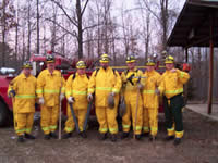
Firefighters from area rural fire department.
Since 2001, the National Park Service (NPS) Rural Fire Assistance (RFA) Program has steadily improved wildland firefighting effectiveness and safety. At Ozark National Scenic Riverways (NSR), funding from RFA has been used to provide personal protective equipment, basic wildland firefighting gear, training, and communications equipment to partnering rural fire departments (RFDs) under cooperative agreements.
In six years at Ozark NSR, $107,823 has been awarded through the RFA program to seven area fire departments that provide initial and extended attack services on wildland fires within the park. In the last five years, those departments have responded to 417 wildland fires on DOI lands.
When the RFA program began at Ozark NSR, only four departments were formally cooperating with DOI/NPS. Today, the number of mutual assistance agreements has increased to include ten fire departments, with protection coverage now extending completely around the park. A primary advantage of RFA is the fire departments have improved a situation in which personal protective equipment was almost totally absent and wildland firefighting tools were rare. However, also importantly - communication between the departments and the park has increased dramatically.
The increased communication led to joint Wildland/Urban Interface (WUI) mapping projects - assessing ignition risk of homes in the WUI, mapping their locations, and providing homeowners with Firewise information about potential mitigation measures. Five fire departments now have baseline information necessary for developing a Community Wildfire Protection Plan (CWPP) and over 3,200 homes in the WUI have been assessed for risk of ignition from a wildland fire, and mapped in a geographic information system (GIS.) This information is also useful to the National Park Service, because it shows where the values at risk lie in relation to park boundaries - which can then be used to establish fuels treatment priorities.
Without RFA, area fire departments would continue to lack basic wildland firefighting tools and equipment. However, since the inception of the Rural Fire Assistance program, their firefighting efforts are now augmented by better communications equipment, more effective tools, and safer gear. At the same time, a positive relationship has grown between the DOI and its partner RFDs.
Contact: Angela Smith, Fire Prevention/Education Specialist
Phone: (573) 323-8234 ext. 21