

National Fire Plan Success Story
Dillonwood Fire Exercise Prepares Federal Partners for Interagency Fire Management
Sequoia and Kings Canyon National Parks, Sequoia National Forest, and Giant Sequoia National Monument, California
National Fire Plan - Accountability
2008
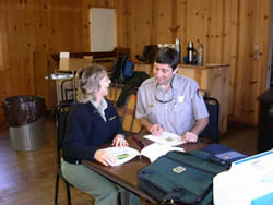
Priscilla Summers, Tule River & Hot Springs District Ranger, and Sequoia National Park District Fire Management Officer Dave Allen discuss their options for managing fire across agency boundaries. NPS photo.
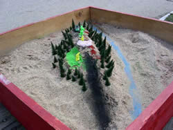
Sand Table Exercises like this one help land managers visualize simulated fire exercises by replicating landscape, forest and fuel types, fire spread, available firefighting response, weather, and other factors. Red represent active fire and black represent burned areas. NPS photo.
Helicopter 552: "I see three lightning fires from the storm. They are in the North Fork of the Tule drainage. All are about one-half acre in size and about one-half mile south Sequoia National Park. Fire behavior is moderate with mainly creeping fire..."
Managers from Sequoia and Kings Canyon National Parks, Sequoia National Forest, and Giant Sequoia National Monument participated in a fire simulation exercise at Ash Mountain Recreation Hall in Sequoia National Park on April 7, 2008.
The exercise, designed by Sequoia National Park District Fire Manager Dave Allen and Tule River Ranger District Fire Manager Paul Gibbs, helped park and forest managers consider actions they would take when wildland fires cross the two agency’s boundaries. Four fires have crossed park and forest boundaries in the past five years.
The exercise challenged managers to determine their response when lightning fires on the Sequoia National Forest and Giant Sequoia National Monument, Tule River Ranger District spread onto National Park Service land in Dillonwood. Issues they needed to respond to in the intensive four-hour scenario included:
- Poor access to the fire area (including access to historic cabins)
- Unnatural fuels including slash piles caused by previous logging practices when the Dillonwood unit was private land - this led to increased fire activity potential near historic structures
- Cultural resources located in the fire area
- Managing smoke to consider impacts to nearby residents and visitors
- Fire in sequoia groves - sequoias thrive and germinate in a natural fire cycle
- Differing land management objectives of each agency
The exercise included initial briefings with maps of the fires and the area they were located, updates on weather, fire spread, and behavior, and an opportunity to visualize the fire area in three dimensions through a sand table replication.
"This exercise was an excellent opportunity for us to discuss and consider these types of events prior to them happening. We were able to determine what actions we could depend upon each other for. After all, we know that natural processes like lightning fires do not stop at the artificial boundaries we have placed," said Craig Axtell, Sequoia and Kings Canyon National Parks Superintendent.
"It provided us a means to meet, learn about the shared issues we face as land managers, and better understand how our interagency response will play out. It also gave us better tools to initiate a response when the scenario becomes reality," said Priscilla Summers, Tule River and Hot Springs District Ranger.
Contact: Deb Schweizer, Fire Communication and Education Specialist, (559) 565-3703.