

National Fire Plan Success Story
Historical Resources Database Pays Dividends for Resource Advisors
Whiskeytown National Recreation Area, California
National Fire Plan - Firefighting
2008
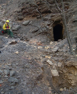
Assessing abandoned mines during the summer fires of 2008.
For several years, Joe Svinarich, the fire program archeologist for several National Park Service units in Northern California, has overseen the creation of a historical resource geospatial database intended to facilitate planning for fuels treatment projects and wildfire response at Whiskeytown National Recreation Area. During the wildfires of June and July 2008, that database proved invaluable as a tool for minimizing the effects of fire and fire management actions on cultural resources, and planning for post-fire emergency stabilization.
Whiskeytown contains a rich record of human occupation, ranging from Native American settlement as early 8,000 years ago to intensive mining operations in the mid-19th to mid-20th centuries. These resources are vulnerable to the effects of wildland fires, fire management operations, and post-fire conditions. With the growth of the fuels program at Whiskeytown and increasingly complex wildland fire seasons, Svinarich realized that minimizing resource impacts from wildland fire required obtaining and organizing as much information on past land-use as possible. Focusing primarily on historic period occupations, data from old maps, land patents, mining claims, photographs, and other sources were compiled, and then scanned, digitized, and incorporated into a Geographic Information System (GIS) platform.
This database worked very well for compliance in advance of fuels projects, guiding Svinarich into areas most likely to contain cultural resources. The system remained largely untested on wildfires until the 2008 fire season, when a massive lightening storm in late June ignited a series of fires in and around Whiskeytown.
Using the database, Svinarich was able to provide information to initial attack resources quickly about the location of recorded sites and sensitive areas, and these were avoided during staging and fireline construction. As the incidents became more complex, the database continued to function well as a resource rapid assessment tool, allowing Incident Command Teams to consider resource issues when making strategic and tactical decisions. Finally, as suppression efforts wound down in mid-July, those engaged in repairing suppression damage and Burned Area Emergency Response (BAER) extensively consulted the database.
Contact: Nelson Siefkin, Archeologist/BAER Coordinator, Pacific West Region and Joe Svinarich, Archeologist, Whiskeytown National Recreation Area; (510) 817-1502 and (530) 242-3458.