
Forests and Rangelands Success Story
Payette Follows Suit with Implementing RedZone
Payette Rural Fire Department, Idaho
National Fire Plan - Firefighting
2008
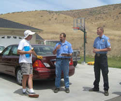
Payette Rural firefighter Justus Barton (center) and resident Greg Frates (left) review the data collected on Frates' home which is then entered into the RedZone geographic mapping and information system. Firefighter Jon Laurenson looks on.
The Payette Rural Fire Department crews are following Weiser’s lead in instituting RedZone software. Crews are in the process of surveying approximately 800 residences and are expected to be completed by September of this year. This program will allow emergency personnel to access GPS coordinates and other pertinent information, allowing a more timely and efficient response to fire incidents.
The RedZone program consists of maps that show topography, location of homes, water sources and hazards in the area. The program also includes photographs of the homes and their wildfire hazard classification of low, moderate, high or extreme wildfire risk. The classification is based on survey questions that pertain to access, topography, vegetation, construction of home and hazards/concerns such as propane tanks and lack of water sources.
"It’s really a benefit to the homeowner as well," according to Local RedZone Coordinator Holly Lefevre. "Property owners will be issued a report letting them know their wildland fire risk rating and what efforts could reduce the threat of damage to personal property in case of a wildland fire."
Payette Fire Chief Jeff Sands recognized the benefits of RedZone while working closely with Weiser Rural Fire Department (RFD) and witnessing their success. Weiser RFD was the first in southwest Idaho to implement this program. "Not only does the software provide us instant access to a wealth of critical information before arriving on the scene of an incident, it also allows us to respond to incidents more quickly and efficiently, which benefits homeowners and the community," Sands said.
During the 2007 fire season, the Sandy Fire consumed over 10,000 acres and threatened dozens of homes in Payette RFD’s jurisdiction. Homeowner Greg Frates directed Bureau of Land Management firefighters to a rural road leading to the fire. "For them to have information about our location is valuable," he said.
The implementation of RedZone is part of the Payette County’s Wildfire Mitigation Plan and funded through a grant from the Bureau of Land Management. Cooperators include Payette Rural Fire, Payette County, Bureau of Land Management, Idaho Department of Lands and the West Central Highlands Resource Conservation and Development.
Contact: Christina Haydon, Boise District Fire Prevention and Information, phone 208-384-3221.