

National Fire Plan Success Story
Wildland Fire Response Guidebook
Beaverhead-Deerlodge National Forest, Montana
National Fire Plan - Firefighting
2008
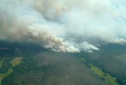
Rat Creek Fire.
The Beaverhead-Deerlodge National Forest, Northern Region, U.S. Forest Service, has developed an operational guide for the management of wildland fire on the Forest, effective fire season, 2009. Why is the development of this guide a success and how is this operational guide significant?
The Forest contains 3.35 million acres across 7 southwest Montana counties and straddles the continental divide. The timber species on the Forest rely on fire as a disturbance to maintain diversity. Development and use of this operational guide is a success because it lays out the foundation for sound decision making for all unplanned wildland fire ignitions across the Forest. The operational guide spatially delineates fire management objectives (from the Land Use Plan), values at risk, resource enhancement opportunities and site specific risk analyses. This local area information enhances decision making opportunities by having the necessary information at line officer and agency administrator fingertips at time of ignition.
Efficient management of unplanned ignitions saves suppression dollars and resources, improves wildlife habitat, and protects community watersheds and all other values at risk. The communities of Wise River, Wisdom, Dillon, Butte, Jefferson, Philipsburg, Deer Lodge, and Whitehall are no strangers to wildland fire. Long duration fires are common in August and September and the risks associated with these events are carefully analyzed.
Site-specific risk analyses were developed for each Landscape Unit using a combination of historical weather and fire history. Potential for large fire growth was correlated to weather and risk assessment tiered to 4 time periods: Early Summer, Summer, Late Summer and Fall. Risk tables developed for each Landscape unit and Forest Plan management area display the large fire growth potential by time period allowing decision makers to make rapid and timely fire management decisions.
Collaboration with county commissioners, federal partners, landowners, and Montana Department of Natural Resources will be ongoing through the winter and spring of 2009. All partners continue to work together toward the fire management goal of cooperative and effective fire management for the upcoming fire season and beyond.
Contact: Tammy Clark, Fire Management Officer, 406-683-3990.