

National Fire Plan Success Story
Antelope2 Fuels Reduction
Malheur National Forest, Oregon
National Fire Plan - Fuels Reduction
1993 to Present
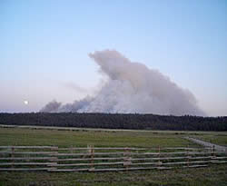
Antelope2 Unit #1 underburn May 2007.
The Malheur National Forest (NF) continues to complete fuels reduction in the forests around the community of Seneca, Oregon. Historically, these ponderosa pine forests had frequent, low intensity fires every 5 to 35 years. Suppression of fire over the past century permitted growth of a denser understory of grand fir, other conifers, and shrubs. This understory has increased ladder fuels that could potentially transform a low intensity ground fire into a fast moving catastrophic crown fire.
Between 1993 and 1998, a series of 1,000 to 4,500-acre prescribed burns were completed successfully each year under the Antelope Prescribed Burning Categorical Exclusion planning document. Informal monitoring results showed minimal tree mortality (less than 5%) in all size classes, well within acceptable limits.
In 2005, the Blue Mountain Ranger District of the Malheur NF completed another planning document, the Antelope2 Environmental Assessment, to continue fuels reduction work in the Seneca area. The project area encompasses 16,620 acres, including 880 acres of private land. The objective is to continue to protect the community- at-risk from wildfire while protecting important plant and wildlife habitat. By the end of 2008, about 7,120 acres have been treated with fire within the Antelope2 Project.
Formal monitoring began in 2006 in various project units using Browns transect fuel plots (designed with FIREMON protocols). Data collected from the fuel plots indicate success in reducing surface fuel loading to levels expected from a more natural fire regime. Further studies will examine the resiliency of native forest vegetation, and impacts of wildfires on soils and aquatic resources.
One of the largest "tree-raking" studies in the Pacific Northwest is being undertaken within a 2,000-acre burn unit. With guidance from the agency’s research branch, data were collected on 500 trees mostly larger than 21 inches diameter. Prior to burning, pine needles were raked away from the bases of half of the 500 trees to potentially reduce root and cambium damage from radiant and convective heat from fire.
Prescribed fire within the project area has burned at intensities and severities similar to historical fires. At this time, ground cover and understory vegetation conditions are meeting National Fire Plan objectives, and are returning to desired conditions described in the Malheur NF Land and Resource Management Plan.
Contact: Steve Cross, Blue Mountain Ranger District Fire Management Officer at (541) 575-3302 or at scross@fs.fed.us.