

National Fire Plan Success Story
RedZone Assessments Completed in Weiser, Idaho
National Fire Plan - Community Assistance
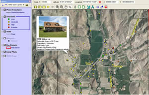
This past summer, Weiser Rural Fire Department crews completed RedZone home assessments on 1163 residents throughout the Weiser Area Rural Fire District. These assessments will assist the fire department in preparing, planning for, and responding to fire incidents. Weiser Rural Fire Department is the first rural fire department in southwest Idaho to utilize GPS/computer mapping technologies to aid emergency response personnel.
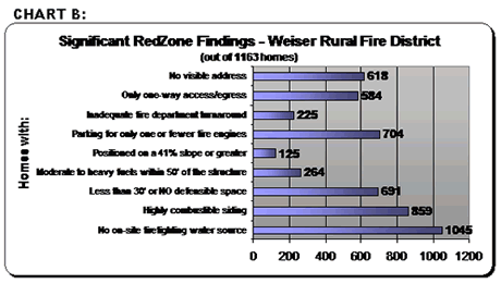
Beginning in June of 2007, every home in the Weiser Area Rural Fire District was assessed for wildfire using an electronic survey. The survey questions pertained to a variety of factors. The factors included access to and from the home, the topography surrounding the home, type of vegetation growing on and near the property, construction of the home (such as roof and siding materials), and other fire protection concerns, such as absence of a water source, propane tanks, amount of defensible space surrounding the property. Upon collection of the data, each home was assigned a wildfire hazard rating number and corresponding classification of low, moderate, high, or extreme wildfire risk, based on its answers to the survey questions.
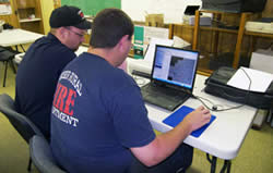
The Weiser Rural Fire Deparment utilized GPS/computer mapping technologies.
Various factors are considered when determining wildfire hazard risk and every home is different; therefore, each home receives a rating based on its own, unique characteristics. Many of the factors that contribute to higher risk ratings are not easy, nor economical to change, such as the home's position on a steep slope, long narrow driveways, minimal room for fire engines to park and/or turn around, homes constructed with combustible materials and heavy vegetation growing near the property. Unfortunately, these factors simply put a home at higher risk of wildfire. Homeowners can take a number of smaller, simpler actions to lower their risk of wildfire significantly. Such actions include but are not limited to: ensuring a clear and visible address at the beginning of the driveway; creating or increasing an effective defensible space; and general clean-up of debris around the home. Although performing these actions may not reduce a home from a "high" to a "moderate" rating, they will undoubtedly improve the home's survivability in the event of a wildfire.
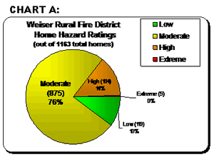
Charts A and B summarize some of the significant data collected during the RedZone assessments. Homes that receive a "high" or "extreme" rating are of the greatest concern to fire managers. All homes in the rural fire district receiving a "high" or "extreme" hazard rating will soon receive a letter in the mail with a full report of their assessment and further information on what they can do to improve or possibly reduce their hazard rating. Those living in the rural fire district interested in receiving a full report of their assessment can contact the Weiser Rural Fire Department.
RedZone will provide instant access to important information about homes.
In addition to helping the fire department prepare and respond to wildfires, RedZone will also assist them in responding to structure fires, as they will have instant access to important information about the home such as the exact location and quickest access to the home, and any other potential hazards or concerns.
The project funded through a Bureau of Land Management grant and the assistance of the West Central Highlands Resource Conservation and Development (WCHRC&D) in Emmett, Idaho has enforced the need to improve private properties susceptible to wildland fire around the Weiser area. The fire department is now looking at potential projects to improve the private properties located in their response area.