

National Fire Plan Success Story
Spearfish Canyon Area Fuels Treatment Projects
Black Hills National Forest, South Dakota
National Fire Plan - Fuels Reduction
2008
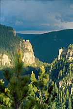
Spearfish Canyon is located in the northwest corner of the Black Hills National Forest, immediately adjacent to the City of Spearfish, South Dakota, on the north end and approximately 8 miles west of the town of Deadwood, South Dakota. It is one of the most notable canyons of the west, proclaimed in the 1930s by world-renowned architect Frank Lloyd Wright as the most magnificent canyon in the West. Spanning nearly one mile in width, 20 miles in length, and over 1,000 feet deep, Spearfish Canyon is 26 times older than the Grand Canyon in geologic time. Numerous side canyons and drainages extend laterally from it. Within these canyons and drainages are four distinct forest vegetative complexes or biomes that have unique plant and animal communities associated with them.
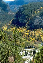
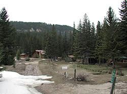
Each year approximately one million visitors are drawn to the scenic vistas, recreational opportunities, unique plant, and animal communities in the Canyon. Because of the unique resources of the Canyon, it has been designated as a State and National Scenic Byway. Five Communities-at-Risk are either directly or indirectly affected or associated with the Canyon. Approximately 150 residences are located within Spearfish Canyon, and another approximate 500 residences are located above the Canyon on either rim. Spearfish Creek, the major watershed within the Canyon, is a wild trout fishery and contributes to the water supply for the City of Spearfish.
During the early settlement of the Spearfish Canyon area, large diameter Ponderosa Pine was harvested from the steep slopes and canyon bottoms for use in area mines and for lumber. In recent years, the ability to perform large-scale harvest in the Canyon has been complicated by competing resources, sensitive species concerns, terrain and watershed constraints, and costs associated with logging the steep slopes. Due to the limited logging, that has taken place within the Canyon during recent years, and successful fire suppression efforts, pine and spruce stands have become denser and are encroaching into areas that may have historically been hardwood areas. This has led to a greater real and perceived threat from wildfire.
Coordinated fuel treatment efforts started in the early 1990s in this area. They were initially concentrated around structures to provide buffers from wildfire, due to the unique resources and high values at risk. In 2002, the "Spearfish Canyon Landscape Assessment" was completed by the U.S. Forest Service which identified issues related to vegetation management, fuels management, watershed management, recreation and scenery management, mineral withdrawal, and land acquisition and zoning. Short and long-term fuels treatment recommendations covered both private and public lands. The treatment recommendations were specific to the ponderosa, spruce, and hardwood cover types. Recommendations were also made for prevention activities, suppression preparedness, and collaboration among stakeholders.
Following the Spearfish Canyon Landscape Assessment recommendations, two separate Categorical Exclusions (CE) for fuels treatments were approved. The Spearfish Canyon 1 Categorical Exclusion proposed 125 acres of thin and hand pile fuel break treatments that have been completed in strategic locations within the Canyon. The Spearfish Canyon 2 Categorical Exclusion proposes 1,120 acres of additional fuel break treatments, prescribed fire, and aspen restoration treatments that are in various stages of completion. The Spearfish Canyon 2 CE (southern one-half of the Canyon) also included 100-foot buffer treatments on Forest Service lands adjacent to private property with structures. Much of the work that has been completed under the two categorical exclusions has been done under force account work utilizing District Forest Service crews, including Ranger District office staff during District Work Days. Hot Shot crews, State of South Dakota hand crews and South Dakota State Department of Correction crews have also completed much of the work through various fuels program funding.
During this time, a Firewise program was being developed for Spearfish Canyon, involving a collaborative effort between Lawrence County, the State of South Dakota, the Spearfish Canyon Owner’s Association, and the Black Hills National Forest Northern Hills Ranger District. Many meetings were held with collaborators over the last six years. The development continues for a Firewise plan for the Canyon. Several interagency Firewise workdays have been held. The Spearfish Canyon Owner’s Association plans to make a formal application for National Firewise Community recognition in the near future.
Prescribed fire fuels treatments were also planned and implemented above the Canyon and to the west with the Griggs Categorical Exclusion. The bulk of the completed work was done with mechanical thinning and mastication contracts for fuels breaks, both to protect private property and for strategic fire suppression purposes. The State of South Dakota was able to secure a federal 100% cost-share grant to conduct fuels treatments on at-risk private lands adjacent to the Griggs project. This collaborative fuels treatment effort was also the impetus that led to the eventual National Firewise Community designation for the adjacent Mountain Plains I and II Subdivisions located on the west Canyon rim near Spearfish.
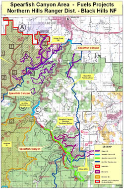
Spearfish Canyon related fuels project implementation continues under several other landscape prescribed fire and fuels treatment projects. These were proposed on either side of the Canyon rim under the Geranium Environmental Assessment, Power Environmental Assessment, Riflepit Environmental Assessment, Mineral Environmental Assessment, and the recently approved Citadel Environmental Impact Statement. Fuels project planning continues within the Canyon and the outlying area under the West Rim planning area. This targets further landscape treatments above Spearfish Canyon and 300-foot structure treatment buffers around homes in the Canyon. The State of South Dakota, Lawrence County, and local homeowner’s groups are again involved in the development of these plans, as well as the eventual cooperative effort that will be needed for successful implementation.
Development of viable fuels treatment projects has been complex and remains so due to the myriad of social, political, financial, and environmental issues that exists within the area. However, through innovative treatment plans and extensive collaboration, effective treatments are being completed and positive public opinion regarding the efforts of the Forest Service and cooperators is being recognized.