

National Fire Plan Success Story
Fire Ecology Data Keeps Bandelier Fire Managers on Track
Bandelier National Monument, New Mexico
National Fire Plan - Rehabilitation
2009
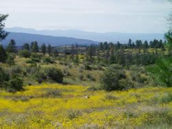
Today grasses and wildflowers are relatively abundant on Escobas Mesa. NPS photo.
Fire ecology data plays an important role in creating objectives for prescribed burns and evaluating the short and long-term effects of fire on the vegetation communities at Bandelier National Monument. The park has been collecting data since 1992. A recent result of this data collection helped park managers decide not to implement a landscape-scale prescribed burn in Escobas Mesa area of the park. Superintendent Brad Traver noted, “The data helps us decide if our Fire Management Program is on the right track, or if we need to adjust our actions. It also helps us decide which areas in the park are priorities for treatment and which areas can be treated at a later time.”
According to Fire Management Officer Gary Kemp, “Data shows the [Escobas Mesa] area is ecologically in good shape right now.” Fire ecologist Laura Trader adds, “The fuel loading is still very low. Smaller diameter trees are low in density. Grasses and wildflowers are relatively abundant.”
The Escobas Mesa area is approximately 3,000 acres of ponderosa pine forest. It is located south and east of the junction of New Mexico (NM) Highway 4 and NM 501. Before widespread fire suppression began in the early 1900s, frequent, low intensity, surface fires maintained an open ponderosa pine forest with individual trees or small clumps of trees spaced widely apart, carpeted with grasses and wildflowers.
The Escobas Mesa area burned intensely during the 1977 human-caused La Mesa Fire. More than twenty years later, fire mangers conducted a prescribed burn in the area in the spring of 1998 and 1999. Fire ecology data collected over the past twelve years show the prescribed burn was a success. Kemp says, “We will continue to collect data and use it to help us decide when to burn that entire area again.”
Bandelier National Monument is still planning a 200-acre prescribed burn along NM Highway 4 in the Escobas Mesa area in 2009. This burn will create a buffer along the park boundary to help reduce the threat of wildfire to the Los Alamos National Laboratory and the community of Los Alamos.
Contact: Gary Kemp, Fire Management Officer, or Laura Trader, Fire Ecologist, (505) 672-3861 ext. 550 or ext. 555.