

National Fire Plan Success Story
Preston-Fox Project Area
Entiat Ranger District, Okanogan-Wenatchee National Forests, Washington
National Fire Plan - Fuels Reduction
2009
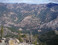
Brennegan and Preston Creeks from Tyee Mountain.
The Preston-Fox Project Area covers over 18,000 acres and includes Preston, Brennegan, McCrea, Burns and Fox Creeks, all of which flow into the mid Entiat River (above Entiat Valley) on the Okanogan-Wenatchee National Forests in Washington. Much of the area was severely burned by the 1970 Entiat Fire. At present the forest ecosystems in the project area are moderately to significantly altered from natural ecological conditions that would have prevailed when low severity fires burned frequently (every 7-12 years) keeping down the understory and favoring fewer trees that were large. The fuels treatments in the Preston-Fox project are designed to restore fire in the ecosystem as well as the type of vegetation (e.g., species, abundance, tree sizes and ages) that likely would have occurred naturally with frequent low severity natural fires.
Preston and Brennegan Creeks, adjacent to private lands and dominated by single-aged ponderosa pine and Douglas-fir stands with a shrub understory, became the main focus for reducing future wildfire intensity and improving vegetative conditions. Managers strived to gain the understanding of local residents of the differences in fire effects and smoke from low-severity prescribed fire versus more intense wildfire, and worked with them to create defensible spaces around their properties. The entire project is Wildland Urban Interface and is supported by a Community Wildfire Protection Plan. In addition, northwest of Brennegan Creek, and between McCrea and Fox Creeks, lies the Entiat Experimental Forest where the project will do experimental prescribed burning in coordination with the USDA Forest Service Pacific Northwest (PNW) Forest Sciences Lab.
Following the first underburn in the area in 2001, planned in coordination with the PNW Forest Sciences Lab, prescribed underburning has been completed on nearly 2000 acres of the Preston-Fox project. In addition, mechanical thinning, followed by piling and burning of slash, has occurred on an additional 1500 acres. Each year, besides reducing the threat of wildfire, the project enhances wildlife habitat by opening up closed-canopy conifer stands resulting in more understory forage and habitat for animals, promoting the growth of aspen by removing competing conifers, and reducing the spread of noxious weeds along road corridors.
Contact: Tom Graham, Entiat (Acting) District Ranger, (509)784-1511, tgraham@fs.fed.us.