

National Fire Plan Success Story
Online Tool Tracks Seasonal Fire Danger in Alaska
National Park Service, Alaska Region
National Fire Plan - Firefighting
2010
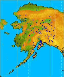
Remote Automated Weather Stations (RAWS) in Alaska.
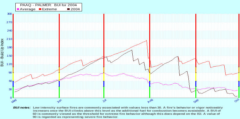
A FWIST user need only identify a pertinent RAWS station, choose a fire index or weather parameter, and select a year to create a graph. In addition, comparative years, average and extreme measured values, and fire danger rating thresholds may be selected to display relative fire danger in the graph. (Click image for a larger version.)
Perhaps you are headed to a remote fire in Alaska and want to get a size up of the potential fire danger before you depart. Perhaps you are an Alaskan fire manager seeking intelligence about the fire danger in an area hundreds of miles away from you’re office because it’s June, hot and dry. Prior to 2009, developing situational awareness about fire danger across the huge state of Alaska was nearly impossible. Weather data and fire weather indices from weather stations scattered throughout the state are available on the Alaska Interagency Coordination Center (AICC) website. However online fire danger tracking tools were minimal or nonexistent because the system Alaska uses for representing fire danger did not work with national tools. Hoping to fill the gap, the NPS Alaska Region Fire Management team developed the Fire Weather Index Seasonal Tracking program (FWIST), an effective and easily accessible online tracking tool. Created in 2009, FWIST is a collaborative effort between Alaska NPS Fire Management and BLM Alaska Fire Service that continues to evolve and improve.
FWIST graphically shows fire indices and related fire weather parameters such as relative humidity, precipitation, and wind speed during Alaska’s fire seasons. The indices presented in FWIST are based on the Canadian Forest Fire Danger Rating System (CFFDRS). CFFDRS is a system identified by fire personnel as the best tool for representing fire danger in Alaskan ecosystems. Fire indices and weather data from all Alaska Remote Automated Weather Stations (RAWS) are continuously updated and can be compared with data as far back as 1994 (in some cases).
Easily accessed online, FWIST is a valuable tool for fire and land managers, planners, and front line firefighters. It also provides useful information to both local and visiting fire personnel. A FWIST user need only identify a pertinent RAWS station, choose a fire index or weather parameter, and select a year to create a graph. In addition, comparative years, average and extreme measured values, and fire danger rating thresholds may be selected to display relative fire danger in the graph.
Fire personnel from Alaskan agencies applaud FWISTs usefulness and have provided tool overviews to a variety of audiences. Look for a summary of FWIST in the BLM 2010 Alaska Handy Dandy Firefighting Field Guide. For access to the tool, visit Alaska Interagency Coordination Center: Predictive Services Fuels / Fire Danger FWI Seasonal Tracking.
Contacts
- Jennifer Mitchell, Fire Ecologist, (907) 455-0656.
- Heidi Strader, Fire Weather Program Manager, (907) 356-5691.