

National Fire Plan Success Story
Junction Lodge Hazardous Fuels Project
Idaho
National Fire Plan - Fuels Reduction
2010
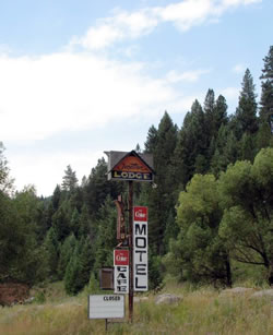
The project area is located around the old Junction Lodge hotel, and adjacent homes. The hotel is currently closed and most home are vacation homes.
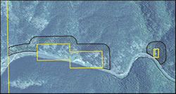
The project area is a 300 foot wide fuel break around the private inholdings at the confluence of Crooked River and the South Fork of the Clearwater River.
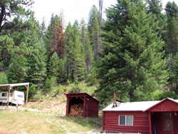
Whiskey Creek before treatment: Fuel loadings were heavy in places due to higher stand densities and mortality.
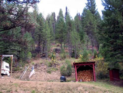
Whiskey Creek after treatment: BLM treatments came close to structures in some locations, but homeowners still maintain responsibility to treat their own property and make their structures defensible.
The Cottonwood Field Office recently completed a wildland-urban interface hazardous fuels reduction project around private in-holdings by Junction Lodge near Elk City, Idaho. The project area, located near the confluence of Crooked River and the South Fork of the Clearwater River in rural Idaho County, is managed by the BLM, with approximately 29 acres of private in-holdings.
Multiple structures, including eight homes and an unoccupied hotel, are situated along the base of the steep slopes of the Clearwater River’s South Fork, where fire once frequented the landscape. Due to fire suppression activities over the past century, fuels have accumulated in the form of Douglas-fir and grand fir regeneration, along with decadent brush and associated litter. The area’s historic fire regime has been altered from low or mixed severity to one of high severity and stand replacement characteristics.
The project, which created a 300 foot wide shaded fuel break adjacent to private property, was designed to lessen the likelihood of a crown fire near private structures and to provide opportunities for controlling an approaching wildfire. Treatment activities included thinning small diameter trees, slashing all brush, and pruning residual trees. Some biomass was utilized as firewood and the slash was hand piled to be burned later this fall.
During the project planning stage, the landowners were contacted to inform them about the proposed project and to initiate homeowner involvement and interest. Initially, there was no response, as most landowners lived outside of the local area. Only one landowner is a full time resident along with a local caretaker residing in another home.
The first day of project implementation, as the chainsaws fired up, both residents were on scene to express interest in the project. The project took four weeks to complete on 41 acres of BLM land, finishing just one day shy of Independence Day, leaving the landowners - many of who were visiting for the weekend –in peace for the holiday.
Within two weeks of completion of the BLM project, chainsaws were once again fired up to complete similar treatment on the private parcels, creating defensible space around the structures. A local non-profit organization, Framing Our Community, had secured the funding through Idaho County grant money and contacted the landowners to pull this project together. Fuels reduction work has been completed around five primary structures to date.
Contact: Kristen Sanders, Fire Ecologist, Cottonwood Field Office, 208-962-3786.