
National Cohesive Wildland Fire Management Strategy Success Story
Minimizing Horseshoe Two Fire Impacts
Chiricahua National Monument, Arizona
Cohesive Strategy - Response to Wildfire
2011
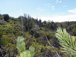
Permanent monitoring plot photos taken on the plateau above Jesse James Canyon before the fire. NPS Photos by Sonoran Desert Network.
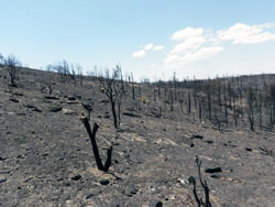
Permanent monitoring plot photos taken on the plateau above Jesse James Canyon after the fire. NPS Photos by Sonoran Desert Network.
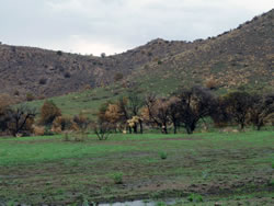
New vegetation is already sprouting post-fire. NPS Photo by Kevin Parris.
On May 8, 2011, the human-caused Horseshoe Two Fire started on the east side of the Chiricahua Mountains near the community of Portal, Arizona. A Type 1 incident management team attempted to suppress the fire, but it continued to grow to the northwest due to extremely dry fuels and steep, inaccessible terrain. On June 8, the fire reached Chiricahua National Monument. A total of 223,000 acres burned within the Chiricahua Mountains; nearly 100% of the monument burned to some extent.
Firefighters cleared brush and fallen leaves from around buildings, removed lower limbs of trees, positioned fire hoses around the historic buildings, wrapped structures including the Stafford Cabin and Sugarloaf lookout, and covered openings of buildings with fire resistant material. As a result of these measures, no park structures were destroyed.
In order to decrease the potential of intense fire in the monument and to protect historic buildings, burnout operations were also utilized after the Horseshoe Two Fire had entered the park. These fires were set during times when the humidity was higher and the winds and temperatures lower. They robbed the main fire of its fuel, burning many areas with relatively low intensity. The burnout fires burned grasses, but many of the larger shrubs and trees survived.
The loss of vegetation because of the fire increased the possibility of post-fire flooding and mudslides. The park has implemented post-fire rehabilitation efforts to minimize these impacts. Drainages have been cleared of downed trees and other debris; and culverts have been cleaned. This is an on-going project and will be repeated after every significant rain event.
On August 2, the National Weather Service (NWS) and National Park Service installed a new weather station in Chiricahua National Monument to replace one damaged by the fire. The NWS continues to monitor the station for rainfall, among other weather elements, in order to issue timely Flash Flood Warnings and Flood Advisories to nearby communities.
The park implemented other fire ecology and restoration projects like assessing trails, removing hazard trees, and working to repair or replace water bars (erosion control structures) and directional signs. In addition, the fire burned a significant portion of the guardrail along the scenic drive. Engineers have assessed the damage; the road will not reopen until repairs have been made.
While the fire burned intensely in some areas of the park, patches of green and natural sources of water are still to be found. For more information, including a podcast, about the Horseshoe Two Fire at the Chiricahua National Monument, please visit the Horseshoe Two Fire - 2011 web page.
Contact
Denise Shultz, Chief of Interpretation
Email: Denise_M_Shultz@nps.gov
Phone: (520) 824-3560 x 307
Keywords: Fire Ecology and Restoration