

National Fire Plan Success Story
Counting Sheep: Interagency Partnership Returns Fire to Forest and Park Safely
Giant Sequoia National Monument (USFS) and Sequoia and Kings Canyon National Parks, California
National Fire Plan - Fuels Reduction
2011
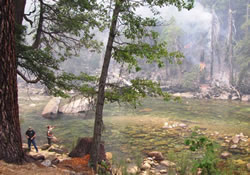
Fishermen recreate along the Kings River across from the Sheep Fire. NPS photo.
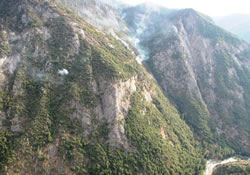
The western containment line of the fire. NPS photo.
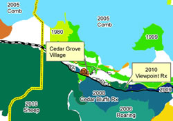
The fire history map of the Cedar Grove area showing a natural mosaic caused by recent fires. NPS photo.
The Sheep Fire was a lightning–ignited fire south of Cedar Grove in Kings Canyon National Park that spread onto the Sequoia National Forest. Close cooperation between the park and the forest helped return fire to this area in a unique year.
Because of the unusually wet and cool year, and because this fire started at a high elevation, an area with tremendous fuels accumulations was treated with a moderate backing fire. It backed into the Monarch Sequoia Grove on the Giant Sequoia National Monument. Sequoias are a fire-adapted species and germinate in a natural fire cycle. The fire burned predominantly across the forest floor, cleaning up the accumulated debris without consuming the stands of trees above it.
The eastern and western flanks of this fire tell a different story. To the east, the 2006 Roaring wildland fire and the 2008 Cedar Bluffs prescribed fire had removed forest fuels that could carry the fire. This example is the result of returning the natural fire mosaic to the area.
In contrast, the western flank had not seen fire in over 100 years as the result of previous suppression actions. Thick forest fuels fed the fire in the steep terrain that is the signature of Kings Canyon. These fuels also created smoky conditions for Cedar Grove, Hume Lake, and east-side communities.
Fire crews took actions to slow or stop the fire’s western spread (for smoke) including a holding line along Lookout Ridge that was compromised in steep cliffs that could not be accessed and the containment line near Deer Meadow. The fire grew to 9,020 acres (3,125 acres on the park, and 5,895 acres on the forest).
Fire staff from the park and forest ensured the response addressed firefighter and public safety, worked closely with the San Joaquin Valley Unified Air Pollution Control District and the California Air Resources Board for smoke management and notification, and allowed visitors to safely see wildland fire in a wilderness setting. Holding actions along the Kings River were a particular highlight.
What does the Sheep Fire accomplish for the parks and forest? The fire started in an area near Cedar Grove that was one of the last areas that had not recently seen fire. It will reduce the risk of an unwanted fire in the upcoming years, promote biodiversity and regeneration, and prevent subsequent fires from being larger, more destructive, and smokier. The agencies appreciate the patience and support of employees and residents who were part of an event that helps preserve these parks (and forest) for future generations.
Contacts
Deb Schweizer, Fire Education Specialist, (559) 565-3703.
Mary Chislock, Public Affairs Officer, Sequoia National Forest and Giant Sequoia National Monument, (559) 784-1500.