
National Cohesive Wildland Fire Management Strategy Success Story
Prior Fuels Reduction Paid Off During Las Conchas Fire
Bandelier National Monument, New Mexico
Cohesive Strategy - Response to Wildfire
2011
The Las Conchas fire started when a tree fell onto a power line at approximately 1:00 PM on June 26, 2011, on private land, about 9 miles west of Bandelier National Monument. The area had experienced its driest period on record, with less than one inch of precipitation for the year. Within two hours, extremely flammable vegetation allowed the fire to grow quickly, pushed by strong winds, toward the east, and into the monument. All park visitors, employees, and residents were evacuated, and the monument was closed. While this evacuation was underway, the Los Alamos Fire Department provided structure protection of National Park Service (NPS) Bandelier National Landmark District buildings.
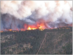
Fire burning toward State Highway 4 in UF 14. NPS photo.
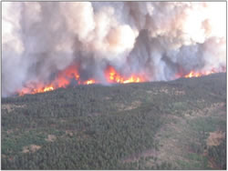
Fire moving across the Mesa top in UF 14. NPS photo.
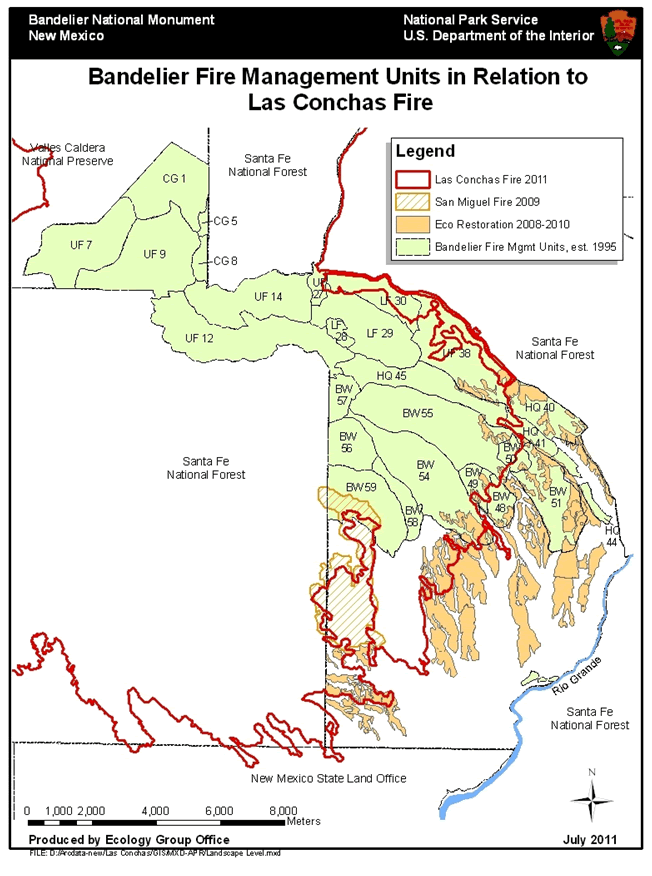
Burn units involved in the Las Conchas Fire (click map for a larger version).
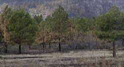
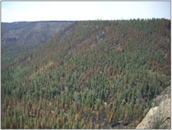
Along most areas visible from Highway 4, fire effects are very light, like this view near Ponderosa Campground. NPS photo.
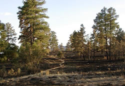
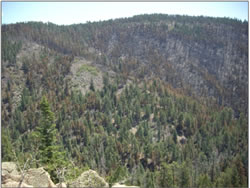
Fire effects were also very light at the beginning of the Burnt Mesa Trail. NPS photo.
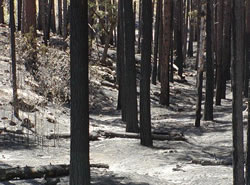
In canyons where no fuels reduction had occurred, many slopes were severely burned. NPS photo.
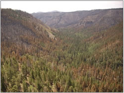
Frijoles Canyon UF 9 treated in foreground UF 12 untreated in background. NPS photo.
Frijoles Canyon UF 9 treated in foreground. UF 12 untreated in background. NPS photo.
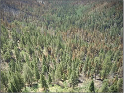
Frijoles Canyon UF 9 looking downstream. NPS photo.
Frijoles Canyon UF 9 Rocky South facing slope. NPS photo.
Firefighters constructed a fire line between the rim of Frijoles Canyon, north of Juniper Campground and the mesa housing area, across the mesa to New Mexico Highway 4. Once this hand line was completed firefighters coordinated a four-part backfire operation aimed at protecting both park infrastructure and keeping the fire from crossing Highway 4.
Nearly 15 miles of blacklining burnout was conducted along New Mexico Highway 4 through the night, providing the critical buffer for Los Alamos National Laboratory and the town of Los Alamos. This line was the first control line of the Las Conchas fire and kept the fire from traversing north of the park’s boundary.
“It is important to note that the burnout along Highway 4 would not have been successful without previous fuels reductions treatments in the area, beginning with the Valle 2 project in 2001,” said Fire Management Officer Gary Kemp. “Every treatment unit in the Monument with the exception of one was burned in this fire under varying degrees of fire severity due to treatments or lack thereof,” Kemp said.
Prior fuel treatments along FS Road 289 and State Highway 4, including thinning, mastication and burning, reduced available fuel loading and tree crown spacing. Crown fire was reduced to ground fire in these areas, providing safer escape routes for local residents as they evacuated and safer travel for emergency vehicles. The treatments also assisted firefighters in detecting and extinguishing spot fires during burnout and holding operations along State Highway 4. Firefighters were able to locate previously prepared firelines in the dark and use them during burnout operations. Also, since the treated areas did not sustain a continuous crown fire there were no major flooding impacts in Frijoles Canyon from this area.
The two private residents within the park boundary were saved as a result of multiple thinning and burning treatments that had been conducted in 2003, 2005, and 2008.
Monday morning, June 27, day two of the fire, firefighters entered Frijoles Canyon and cut a rim-to-rim fire line, approximately two tenths of a mile north of Alcove House. Crews then ignited a backburn north of the line working to create a blackline buffer between the rapidly advancing fire within Frijoles Canyon and the NPS Bandelier National Landmark District. Over the next 24-36 hours, crews battled to maintain this fire line, requiring assistance of air dropped retardant and water drops from air tankers and heavy lift helicopters to hold the line. The line eventually held and stopped the rapidly advancing fire from entering the NPS Bandelier National Landmark District, thereby saving all of the buildings, infrastructure and cultural resources from being overrun by the fire.
A 300-acre broadcast burn conducted in 2009 was a key feature that provided firefighters a place to stop the fire from proceeding down canyon toward the headquarters area. Firefighters were able to safely burn out Frijoles Canyon and stop the progress of the fire.
The area of the park that did not sustain fire was where the San Miguel Fire had been managed for resource benefits in 2009. Low to moderate burn intensities in this area were the norm.
In addition, “The Cerro Grande fire helped save Los Alamos, because while this fire did burn across the landscape, it burned less severely," said Chief of Interpretation Rod Torres.
When the fire reached the old Cerro Grande burn area, it dropped the fire to the ground and slowed it down. While the fire burned through an estimated 10,000 acres of the old Cerro Grande burn area, moderated fire behavior in the area provided firefighters an opportunity to engage and take action to contain the fire. Extensive thinning around the city of Los Alamos at the Los Alamos Nuclear Laboratory also helped create a buffer.
"In the areas where the treatments had been done, it was evident that the fire was not as severe," Torres said.
Within the first 13 hours the Las Conchas Fire burned over 44,000 acres, more than a third of it within Bandelier National Monument, at a rate of almost an acre a second. Numerous communities were threatened during the incident. Only one structure, a backcountry patrol cabin in Capulin Canyon, was destroyed in Bandelier National Monument. Thirty-five days later, on August 3, the fire was contained at 156,593 acres, the largest wildfire in New Mexico history. Ultimately, 20,800 acres, or 62 percent, of the Bandelier National Monument had burned.
For additional information about the Bandelier National Monument Fire Management program, please visit their Fire Management website.
Contact: Gary Kemp, Fire Management Officer, Gary_Kemp@nps.gov, 505-672-3861 x550.
Keywords: Partnerships, Fire Ecology and Restoration, Protecting Communities